Tiedosto:Map-Germany-1945.svg

Wikipediasta
Siirry navigaatioon Siirry hakuun

Alkuperäinen tiedosto(SVG-tiedosto; oletustarkkuus 3 492 × 2 966 kuvapistettä; tiedostokoko 726 KiB)

Yhteenveto

Kuvaus
العربية: حدود المناطق المحتلة في ألمانيا عام 1957. الاراضي شرق خط نيس تحت السيطرة البولندية والسوفييتية، تظهر بلون ابيض. برلين منطقة مسيطر عليها من عدة بلدان داخل المنطقة السوفييتة.
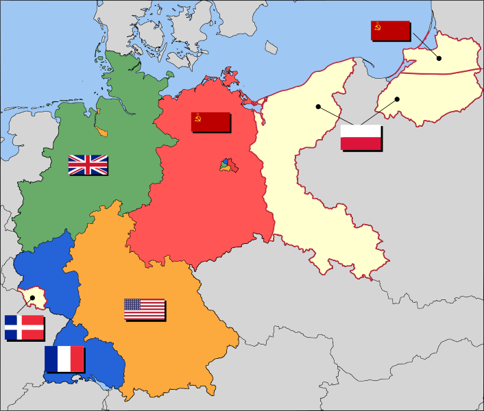
English: Occupation zone borders in Germany, 1947. The territories east of the Oder-Neisse line, under Polish and Soviet administration/annexation, are shown as cream as is the likewise detached Saar protectorate. Berlin is the multinational area within the Soviet zone.
Français : Carte des zones d'occupation de l'Allemagne : le protectorat français de la Sarre apparait en blanc-crème, comme la Silésie, la Poméranie et les autres régions allemandes orientales annexées par la Pologne et l'Union Soviétique.
Deutsch: Grenzen der Besatzungszonen in Deutschland, 1947. Die Gebiete östlich der Oder-Neiße-Grenze, unter polnischer und sowjetischer Verwaltung/Annexion, sowie das Saar-Protektorat sind cremefarben dargestellt. Berlin ist ein multinationales Gebiet inmitten der sowjetischen Besatzungszone.
Päiväys 17. maaliskuuta 2008 (alkuperäinen tallennuspäivä)
Lähde Based on map data of the IEG-Maps project (Andreas Kunz, B. Johnen and Joachim Robert Moeschl: University of Mainz) - www.ieg-maps.uni-mainz.de.
Tekijä User:52 Pickup
SVG kehittely
InfoField
 
Tämä SVG-tiedosto on viallinen, koska siinä on 11 virhettä.
 
Tämä vektorigrafiikkatiedosto luotiin käyttäen apuna ohjelmaa Inkscape.

Lisenssi

w:fi:Creative Commons
nimeäminen jaa samoin
Tämä tiedosto on lisensoitu Creative Commons Nimeä-JaaSamoin 2.5 Yleinen -lisenssillä.
Voit:
  • jakaa – kopioida, levittää ja esittää teosta
  • remiksata – valmistaa muutettuja teoksia
Seuraavilla ehdoilla:
  • nimeäminen – Sinun on mainittava lähde asianmukaisesti, tarjottava linkki lisenssiin sekä merkittävä, mikäli olet tehnyt muutoksia. Voit tehdä yllä olevan millä tahansa kohtuullisella tavalla, mutta et siten, että annat ymmärtää lisenssinantajan suosittelevan sinua tai teoksen käyttöäsi.
  • jaa samoin – Jos muutat tai perustat tähän työhön, voit jakaa tuloksena syntyvää työtä vain tällä tai tämän kaltaisella lisenssillä.

Alkuperäinen tallennusloki

Siirretty projektista en.wikipedia Commonsiin käyttäjän Broadbeer toimesta työkalulla CommonsHelper.

Alkuperäinen kuvaussivu oli täällä. Käyttäjätunnukset alla viittaavat kohteeseen en.wikipedia.
  • 2008-03-17 19:50 52 Pickup 3492×2966× (760290 bytes) Changes to fill and border colours. Made differences clearer between occupation zones and eventual territorial losses.
  • 2007-08-31 14:57 52 Pickup 3492×2966× (755561 bytes) New version: regions placed under Polish and Soviet administration now presented slightly differently (borders instead of colour fill), Saar colour now only slightly different to French zone (still needs some work)
  • 2007-08-10 09:50 52 Pickup 3492×2966× (751829 bytes) oops, now with fixed image size
  • 2007-08-10 09:47 52 Pickup 744×1052× (751774 bytes) {{Information| |Description= Germany in the aftermath of World War II: 1 September 1945 |Source= Based on map data of the IEG-Maps project (Andreas Kunz, B. Johnen and Joachim Robert Moeschl: University of Mainz) - [http://www.ieg-maps.uni-mainz.de www.ie
Annotations
InfoField
This image is annotated: View the annotations at Commons

Kuvatekstit

Lisää yhden rivin pituinen kuvaus tästä tiedostosta
Occupation map of Germany after WW2

Kohteet, joita tässä tiedostossa esitetään

esittää

17. maaliskuu 2008

Tiedoston historia

Päiväystä napsauttamalla näet, millainen tiedosto oli kyseisellä hetkellä.

PäiväysPienoiskuvaKokoKäyttäjäKommentti
nykyinen1. joulukuuta 2017 kello 07.37Pienoiskuva 1. joulukuuta 2017 kello 07.37 tallennetusta versiosta3 492 × 2 966 (726 KiB)SammimackUpdated flags and colours
3. heinäkuuta 2015 kello 17.13Pienoiskuva 3. heinäkuuta 2015 kello 17.13 tallennetusta versiosta3 492 × 2 966 (728 KiB)LichaoshengNew 48-Star US Flag from File:US flag 48 stars.svg
3. heinäkuuta 2015 kello 17.00Pienoiskuva 3. heinäkuuta 2015 kello 17.00 tallennetusta versiosta3 492 × 2 966 (742 KiB)LichaoshengReverted to version as of 18:46, 8 October 2008
4. helmikuuta 2012 kello 18.19Pienoiskuva 4. helmikuuta 2012 kello 18.19 tallennetusta versiosta3 492 × 2 966 (742 KiB)AnonMoosReverted to version as of 18:46, 8 October 2008 -- Kaliningrad had quite different status and fate from that of East Germany proper...
20. tammikuuta 2012 kello 22.44Pienoiskuva 20. tammikuuta 2012 kello 22.44 tallennetusta versiosta3 492 × 2 966 (742 KiB)Sammy pomponKaliningrado is occuped by USSR.
8. lokakuuta 2008 kello 21.46Pienoiskuva 8. lokakuuta 2008 kello 21.46 tallennetusta versiosta3 492 × 2 966 (742 KiB)File Upload Bot (Magnus Manske) {{BotMoveToCommons|en.wikipedia}} {{Information |Description={{en|Occupation zone borders in Germany, 1947. The territories east of the en:Oder-Neisse line, under Polish and Soviet administration/annexation, are shown as white as is the likewise det

Seuraavat 2 sivua käyttävät tätä tiedostoa:

Tiedoston järjestelmänlaajuinen käyttö

Seuraavat muut wikit käyttävät tätä tiedostoa:

Näytä lisää tämän tiedoston järjestelmänlaajuista käyttöä.

Metatieto