Tiedosto:Location-Europe-UNsubregions, Kosovo as part of Serbia.png
Siirry navigaatioon
Siirry hakuun

Tämän esikatselun koko: 638 × 599 kuvapistettä. Muut resoluutiot: 256 × 240 kuvapistettä | 511 × 480 kuvapistettä | 984 × 924 kuvapistettä.
Alkuperäinen tiedosto (984 × 924 kuvapistettä, 50 KiB, MIME-tyyppi: image/png)
| Tämä tiedosto on tiedostotietokanta Wikimedia Commonsista. Tiedot kuvaussivulta näkyvät alla. |  |
Tiedoston kuvaussivu Commonsissa |

|
Tästä tiedostosta on saatavilla myös SVG-versio eli vektorigrafiikkatiedosto. SVG-versiota tulisi suosia, mikäli se on laadultaan tätä rasterikuvaa parempi.
File:Location-Europe-UNsubregions, Kosovo as part of Serbia.png → File:Europe subregion map UN geoscheme.svg
|
 |

|
This map has been uploaded by Electionworld from en.wikipedia.org to enable the |
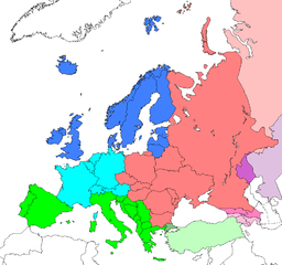
Map: Europe (location), subregions as delineated by United Nations geographic classification scheme:
- Asian portions of these countries
- Asian portions of these countries
Countries of Central Asia with partial territory in Eastern Europe – Kazakhstan
- Asian portions of these countries
Lisenssi
| Tämän teoksen tekijä, Electionworld, on julkaissut sen public domainiin. Tämä on voimassa maailmanlaajuisesti. Joissain maissa laki ei mahdollista tätä. Mikäli näin on: |
Alkuperäinen tallennusloki
| date/time | username | resolution | size | edit summary |
|---|---|---|---|---|
| 16:25, 10 June 2008 | User:Milosevo | 984×924 | 50 KB | STOP VANDALISING! KOSOVO ISN'T A UN MEMBER, SO KOSOVO CAN'T BE IN A UN SUBREGION! |
| 13:28, 10 June 2008 | User:Cradel | 638×599 | 166 KB | Reverted to version as of 20:44, 9 June 2008jere |
| 12:07, 10 June 2008 | User:Milosevo | 984×924 | 50 KB | Reverted, again: kosovo isn't UN member, so it can't be in an UN subregion. |
| 20:44, 9 June 2008 | User:Cradel | 638×599 | 166 KB | Reverted to version as of 20:16, 8 June 2008 |
| 14:15, 9 June 2008 | User:Milosevo | 984×924 | 50 KB | kosovo isn't a UN member, so it can't be in an UN subregion. |
| 20:16, 8 June 2008 | User:Cradel | 638×599 | 166 KB | Reverted to version as of 18:17, 1 May 2008 |
| 10:17, 8 June 2008 | User:Milosevo | 984×924 | 50 KB | Reverted to version as of 23:06, 30 April 2008 |
| 18:17, 1 May 2008 | User:Cradel | 638×599 | 166 KB | Reverted vandalism |
| 23:06, 30 April 2008 | User:Serbish | 984×924 | 50 KB | Reverted to version as of 23:01, 29 January 2008 |
| 20:53, 7 April 2008 | User:Cradel | 638×599 | 166 KB | + Kosovo |
| 23:01, 29 January 2008 | User:Mahahahaneapneap | 984×924 | 50 KB | pngcrushed |
| 14:46, 3 December 2006 | User:Electionworld | 984×924 | 73 KB | {{ew|en|Cogito ergo sumo}} Map: <a href="/wiki/Europe" class="mw-redirect" title="Europe">Europe</a> (location), <a href="/w/index.php?title=Subregion&action=edit&redlink=1" class="new" title="Subregion (page does not exist)">subregions</a> as delineated by [http://unstats.un.org/unsd/methods/m49/m49regin.htm United Nations geographic classification scheme]:<br> {{legend|#4080FF|<a href="/w/index.php?title=Northern_Europe&action=edit&redlink=1" class="new" title="Northern Europe (page does not exist)">Northern Europe</a>}} {{legend|#00FFFF|[[Wes |
Tiedoston historia
Päiväystä napsauttamalla näet, millainen tiedosto oli kyseisellä hetkellä.
| Päiväys | Pienoiskuva | Koko | Käyttäjä | Kommentti | |
|---|---|---|---|---|---|
| nykyinen | 8. elokuuta 2008 kello 18.17 | | 984 × 924 (50 KiB) | BetacommandBot | move approved by: User:Samulili This image was moved from Image:Location-Europe-UNsubregions.png {{ew|en|Cogito ergo sumo}} Map: Europe (location), subregions as delineated by [http://unstats.un.org/unsd/methods/m49/m49regin.htm United |
Tiedoston käyttö
Seuraavat 2 sivua käyttävät tätä tiedostoa:
Tiedoston järjestelmänlaajuinen käyttö
Seuraavat muut wikit käyttävät tätä tiedostoa:
- Käyttö kohteessa ace.wikipedia.org
- Käyttö kohteessa af.wikipedia.org
- Käyttö kohteessa ar.wikipedia.org
- Käyttö kohteessa be-tarask.wikipedia.org
- Käyttö kohteessa be.wikipedia.org
- Käyttö kohteessa bg.wikipedia.org
- Käyttö kohteessa bn.wikipedia.org
- Käyttö kohteessa br.wikipedia.org
- Käyttö kohteessa bs.wikipedia.org
- Käyttö kohteessa ceb.wikipedia.org
- Käyttö kohteessa crh.wikipedia.org
- Käyttö kohteessa cy.wikipedia.org
- Käyttö kohteessa da.wikipedia.org
- Käyttö kohteessa en.wikipedia.org
- Käyttö kohteessa en.wikivoyage.org
- Käyttö kohteessa eo.wikipedia.org
- Käyttö kohteessa eu.wikipedia.org
- Käyttö kohteessa fa.wikipedia.org
- Käyttö kohteessa fr.wikipedia.org
- Käyttö kohteessa fy.wikipedia.org
- Käyttö kohteessa fy.wiktionary.org
- Käyttö kohteessa gag.wikipedia.org
- Käyttö kohteessa gd.wikipedia.org
- Käyttö kohteessa gl.wikipedia.org
- Käyttö kohteessa id.wikipedia.org
- Käyttö kohteessa io.wikipedia.org
- Käyttö kohteessa ja.wikivoyage.org
Näytä lisää tämän tiedoston järjestelmänlaajuista käyttöä.