Tiedosto:Karte Slowakischer Nationalaufstand 1944 - Aufstandsbeginn.png

Alkuperäinen tiedosto (2 013 × 1 107 kuvapistettä, 1,96 MiB, MIME-tyyppi: image/png)
| Tämä tiedosto on tiedostotietokanta Wikimedia Commonsista. Tiedot kuvaussivulta näkyvät alla. |  |
Tiedoston kuvaussivu Commonsissa |
Yhteenveto
| Kuvaus |
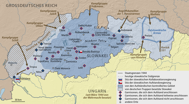
Deutsch: Karte zum Aufstandsbeginn des Slowakischen Nationalaufstands 1944 |
| Päiväys | |
| Lähde |
Own work using:
|
| Tekijä | NordNordWest |
| Muut versiot |
|


|
Saksankielisen Wikipedian projekti Kartenwerkstatt on parantanut tätä karttaa. Myös sinä voit ehdottaa jotakin karttaa parannettavaksi.
|
Lisenssi
Usage of this file with:

explanatory notes: Legally binding is only the full legalcode. For a free usage I recommend to respect the following licence conditions:
1. Provide my name as given above: NordNordWest,
2. a copy of, or the URI for, the applicable license: https://creativecommons.org/licenses/by-sa/3.0/de/legalcode,
3. the title of the work,
4. in the case of an adaptation, a credit identifying the use of the work in the adaptation.
This license and the rights granted hereunder will terminate automatically upon any breach by you of the terms of this license. Any of the above conditions can be waived if you get permission from the copyright holder. If you have questions or wish differing conditions, please contact me through nnwest or my discussion page ![]() t-online.de
t-online.de
- Voit:
- jakaa – kopioida, levittää ja esittää teosta
- remiksata – valmistaa muutettuja teoksia
- Seuraavilla ehdoilla:
- nimeäminen – Sinun on mainittava lähde asianmukaisesti, tarjottava linkki lisenssiin sekä merkittävä, mikäli olet tehnyt muutoksia. Voit tehdä yllä olevan millä tahansa kohtuullisella tavalla, mutta et siten, että annat ymmärtää lisenssinantajan suosittelevan sinua tai teoksen käyttöäsi.
- jaa samoin – Jos muutat tai perustat tähän työhön, voit jakaa tuloksena syntyvää työtä vain tällä tai tämän kaltaisella lisenssillä.


|
This image has been assessed under the valued image criteria and is considered the most valued image on Commons within the scope: Maps of the Slovak National Uprising, showing the beginning of the uprising. You can see its nomination here. |
Tiedoston historia
Päiväystä napsauttamalla näet, millainen tiedosto oli kyseisellä hetkellä.
| Päiväys | Pienoiskuva | Koko | Käyttäjä | Kommentti | |
|---|---|---|---|---|---|
| nykyinen | 29. helmikuuta 2020 kello 21.40 | | 2 013 × 1 107 (1,96 MiB) | NordNordWest | c |
| 29. helmikuuta 2020 kello 21.32 |  | 2 013 × 1 107 (1,99 MiB) | NordNordWest | c | |
| 29. helmikuuta 2020 kello 21.28 |  | 2 013 × 1 107 (1,96 MiB) | NordNordWest | c | |
| 31. toukokuuta 2015 kello 13.10 |  | 2 013 × 1 107 (2,01 MiB) | NordNordWest | corr | |
| 27. toukokuuta 2015 kello 22.06 |  | 2 013 × 1 107 (2 MiB) | NordNordWest | == {{int:filedesc}} == {{Information |Description= {{de|1=Karte zum Aufstandsbeginn des Slowakischen Nationalaufstands 1944}} |Source={{Own using}} * United States National Imagery and Mapping Agency data * SRTM30 v.2 data |Date={{Date|2015|05|27}} |Au... |
Tiedoston käyttö
Tätä tiedostoa ei käytetä millään sivulla.
Tiedoston järjestelmänlaajuinen käyttö
Seuraavat muut wikit käyttävät tätä tiedostoa:
- Käyttö kohteessa de.wikipedia.org
- Käyttö kohteessa sr.wikipedia.org