Tiedosto:Kansai closeup.jpg
Siirry navigaatioon
Siirry hakuun
Tarkempaa kuvaa ei ole saatavilla.
Kansai_closeup.jpg (800 × 600 kuvapistettä, 66 KiB, MIME-tyyppi: image/jpeg)
| Tämä tiedosto on tiedostotietokanta Wikimedia Commonsista. Tiedot kuvaussivulta näkyvät alla. |  |
Tiedoston kuvaussivu Commonsissa |
Yhteenveto
| Kuvaus |
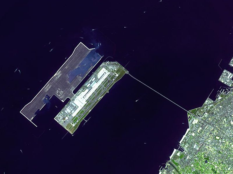
Satellite image of Kansai International Airport in Osaka Bay in Japan. This is a closeup - for an overview image showing the airport on its artificial island in the bay, see Image:Wfm kansai overview.jpg |
| Päiväys | |
| Lähde |
Taken from an uncopyrighted image NASA Earth Observatory |
| Tekijä | NASA Earth Observatory |
| Käyttöoikeus (Tämän tiedoston uudelleenkäyttö) |
"The purpose of NASA's Earth Observatory is to provide a freely-accessible publication on the Internet where the public can obtain new satellite imagery and scientific information about our home planet. The focus is on Earth's climate and environmental change. In particular, we hope our site is useful to public media and educators. Any and all materials published on the Earth Observatory are freely available for re-publication or re-use, except where copyright is indicated. We ask that NASA's Earth Observatory be given credit for its original materials." |
| Muut versiot |

| Kohteen sijainti | | Tämä ja muut kuvat kartalla: OpenStreetMap |
|---|
Lisenssi
| Tämä teos on ilman tekijänoikeuden suojaa, koska National Aeronautics and Space Administration (NASA) loi sen. Koska Nasa on Yhdysvaltain liittovaltion organisaatio, sen luomat teokset ovat ilman tekijänoikeuden suojaa. ([1][2]) | ||
 |
Varoitukset:
|
en.Wikipedia upload log
The en.Wikipedia description page is/was here. All following user names refer to en.Wikipedia.
- 2004-04-05 19:30 Finlay McWalter 800×600 (66 KB) (nasa image of kansai airport)
Tiedoston historia
Päiväystä napsauttamalla näet, millainen tiedosto oli kyseisellä hetkellä.
| Päiväys | Pienoiskuva | Koko | Käyttäjä | Kommentti | |
|---|---|---|---|---|---|
| nykyinen | 13. joulukuuta 2005 kello 06.46 | | 800 × 600 (66 KiB) | Sam916~commonswiki | Satellite image of Kansai International Airport in Osaka Bay in Japan. This is a closeup - for an overview image showing the airport on its artificial island in the bay, see Image:Wfm kansai overview.jpg Taken from an uncopyrighted imag |
Tiedoston käyttö
Seuraava sivu käyttää tätä tiedostoa:
Tiedoston järjestelmänlaajuinen käyttö
Seuraavat muut wikit käyttävät tätä tiedostoa:
- Käyttö kohteessa ar.wikipedia.org
- Käyttö kohteessa ast.wikipedia.org
- Käyttö kohteessa bbc.wikipedia.org
- Käyttö kohteessa bg.wikipedia.org
- Käyttö kohteessa bh.wikipedia.org
- Käyttö kohteessa bn.wikipedia.org
- Käyttö kohteessa de.wikipedia.org
- Käyttö kohteessa el.wikipedia.org
- Käyttö kohteessa en.wikipedia.org
- Käyttö kohteessa en.wikibooks.org
- Käyttö kohteessa es.wikipedia.org
- Käyttö kohteessa eu.wikipedia.org
- Käyttö kohteessa fa.wikipedia.org
- Käyttö kohteessa he.wikipedia.org
- Käyttö kohteessa hu.wikipedia.org
- Käyttö kohteessa id.wikipedia.org
- Käyttö kohteessa io.wikipedia.org
- Käyttö kohteessa it.wikipedia.org
- Käyttö kohteessa it.wikivoyage.org
- Käyttö kohteessa ja.wikipedia.org
- Käyttö kohteessa ko.wikipedia.org
- Käyttö kohteessa lfn.wikipedia.org
- Käyttö kohteessa ml.wikipedia.org
- Käyttö kohteessa mn.wikipedia.org
- Käyttö kohteessa ms.wikipedia.org
- Käyttö kohteessa nl.wikipedia.org
- Käyttö kohteessa pt.wikipedia.org
- Käyttö kohteessa ro.wikipedia.org
- Käyttö kohteessa simple.wikipedia.org
- Käyttö kohteessa sl.wikipedia.org
- Käyttö kohteessa sr.wikipedia.org
- Käyttö kohteessa sv.wikipedia.org
- Käyttö kohteessa ta.wikipedia.org
- Käyttö kohteessa uk.wikipedia.org
- Käyttö kohteessa vi.wikipedia.org
- Käyttö kohteessa www.wikidata.org
- Käyttö kohteessa zh-yue.wikipedia.org
- Käyttö kohteessa zh.wikipedia.org
Näytä lisää tämän tiedoston järjestelmänlaajuista käyttöä.