Tiedosto:IslamicConquestsIroon.png
Siirry navigaatioon
Siirry hakuun
Tämän esikatselun koko: 675 × 599 kuvapistettä. Muut resoluutiot: 270 × 240 kuvapistettä | 541 × 480 kuvapistettä | 1 006 × 893 kuvapistettä.
Alkuperäinen tiedosto (1 006 × 893 kuvapistettä, 105 KiB, MIME-tyyppi: image/png)
| Tämä tiedosto on tiedostotietokanta Wikimedia Commonsista. Tiedot kuvaussivulta näkyvät alla. |  |
Tiedoston kuvaussivu Commonsissa |

|
Tämä tyyppiä historical map oleva kuva pitäisi luoda uudelleen SVG-tiedostoksi vektorigrafiikan avulla. Tällä tiedostotyypillä on monia vahvuuksia, sivulta Commons:Media for cleanup löytyy lisätietoja. Jos tästä kuvasta on jo olemassa SVG-versio, ole ystävällinen ja tallenna se tänne. SVG-tiedoston tallentamisen jälkeen vaihda tämä malline mallineeseen {{vector version available|uusi kuvan nimi.svg}}.
|
| Kuvaus |
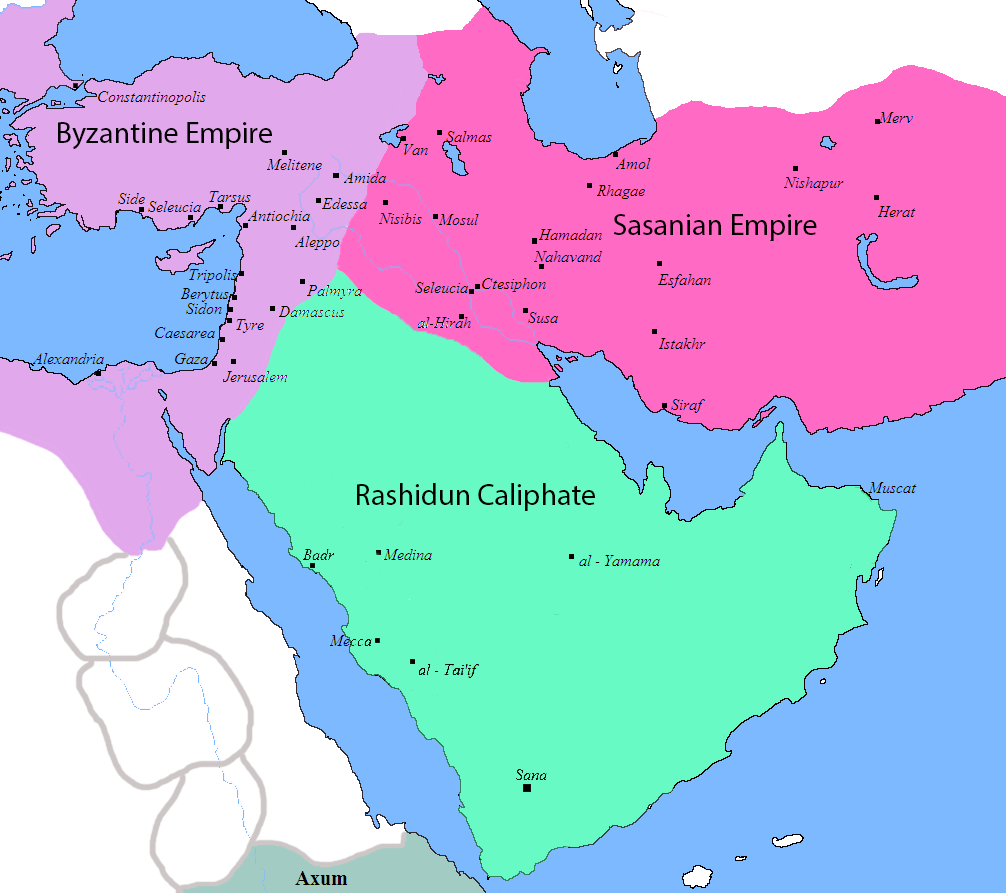
English: Map of the Sassanid, Byzantine and Muslim borders. |
| Lähde | File:Pre_Islamic_Arabia.PNG |
| Tekijä | Javierfv1212 and edited by HistoryofIran. |
| Muut versiot |
[]
|


This file is in the public domain because File:Pre_Islamic_Arabia.PNG
|
Tiedoston historia
Päiväystä napsauttamalla näet, millainen tiedosto oli kyseisellä hetkellä.
| Päiväys | Pienoiskuva | Koko | Käyttäjä | Kommentti | |
|---|---|---|---|---|---|
| nykyinen | 18. syyskuuta 2019 kello 13.13 | | 1 006 × 893 (105 KiB) | HistoryofIran | rv, thats not how it works |
| 18. syyskuuta 2019 kello 07.51 |  | 1 006 × 893 (103 KiB) | Сахалин21 | Under Hormizd IV, Persia won the Perso-Turkic War and conquered Samarqand and the Transoxiania. | |
| 18. syyskuuta 2019 kello 07.50 |  | 1 006 × 893 (105 KiB) | Сахалин21 | Reverted to version as of 01:15, 3 August 2019 (UTC) | |
| 18. syyskuuta 2019 kello 07.45 |  | 1 006 × 893 (103 KiB) | Сахалин21 | Reverted to version as of 19:13, 14 November 2017 (UTC) | |
| 3. elokuuta 2019 kello 04.15 |  | 1 006 × 893 (105 KiB) | HistoryofIran | rv, no, they weren't at all | |
| 1. elokuuta 2019 kello 21.38 |  | 1 006 × 893 (105 KiB) | Mehrdad 12 | The eastern borders were conquered during the reign of Queen Purandokht. | |
| 1. elokuuta 2019 kello 21.34 |  | 1 006 × 893 (106 KiB) | Mehrdad 12 | I corrected the eastern borders. The Great Khorasan and Khwarizmi Desert were considered imperial. | |
| 12. helmikuuta 2019 kello 05.51 |  | 1 006 × 893 (105 KiB) | HistoryofIran | Made the map somewhat more accurate, probably more to come. | |
| 14. marraskuuta 2017 kello 22.13 |  | 1 006 × 893 (103 KiB) | HistoryofIran | rv, the Sasanian Empire didnt control that much | |
| 12. marraskuuta 2017 kello 14.02 |  | 1 006 × 893 (128 KiB) | Mehrdad 12 | {{NAMESPACE}}{{PAGENAME}}[[]][[:File:]]]] |
Tiedoston käyttö
Seuraavat 2 sivua käyttävät tätä tiedostoa:
Tiedoston järjestelmänlaajuinen käyttö
Seuraavat muut wikit käyttävät tätä tiedostoa:
- Käyttö kohteessa bg.wikipedia.org
- Käyttö kohteessa bn.wikipedia.org
- Käyttö kohteessa bn.wikiquote.org
- Käyttö kohteessa bs.wikipedia.org
- Käyttö kohteessa cs.wikipedia.org
- Käyttö kohteessa da.wikipedia.org
- Käyttö kohteessa de.wikipedia.org
- Käyttö kohteessa diq.wikipedia.org
- Käyttö kohteessa en.wikipedia.org
- Käyttö kohteessa fa.wikipedia.org
- Käyttö kohteessa fa.wikibooks.org
- Käyttö kohteessa fr.wikipedia.org
- Käyttö kohteessa he.wikipedia.org
- Käyttö kohteessa hr.wikipedia.org
- Käyttö kohteessa hy.wikipedia.org
- Käyttö kohteessa hyw.wikipedia.org
- Käyttö kohteessa ka.wikipedia.org
- Käyttö kohteessa ko.wikipedia.org
- Käyttö kohteessa ru.wikipedia.org
- Käyttö kohteessa sr.wikipedia.org
- Käyttö kohteessa sv.wikipedia.org
- Käyttö kohteessa ta.wikipedia.org
- Käyttö kohteessa th.wikipedia.org
- Käyttö kohteessa tr.wikipedia.org
- Käyttö kohteessa uk.wikipedia.org
- Käyttö kohteessa zh.wikipedia.org