Tiedosto:Herodotus world map-en.svg
Siirry navigaatioon
Siirry hakuun

Tämän PNG-esikatselun koko koskien SVG-tiedostoa: 788 × 476 kuvapistettä. Muut resoluutiot: 320 × 193 kuvapistettä | 640 × 387 kuvapistettä | 1 024 × 619 kuvapistettä | 1 280 × 773 kuvapistettä | 2 560 × 1 546 kuvapistettä.
Alkuperäinen tiedosto (SVG-tiedosto; oletustarkkuus 788 × 476 kuvapistettä; tiedostokoko 319 KiB)
| Tämä tiedosto on tiedostotietokanta Wikimedia Commonsista. Tiedot kuvaussivulta näkyvät alla. |  |
Tiedoston kuvaussivu Commonsissa |
Tämä vektorigrafiikkatiedosto luotiin käyttäen apuna ohjelmaa Inkscape .
| Kuvailu |
[]
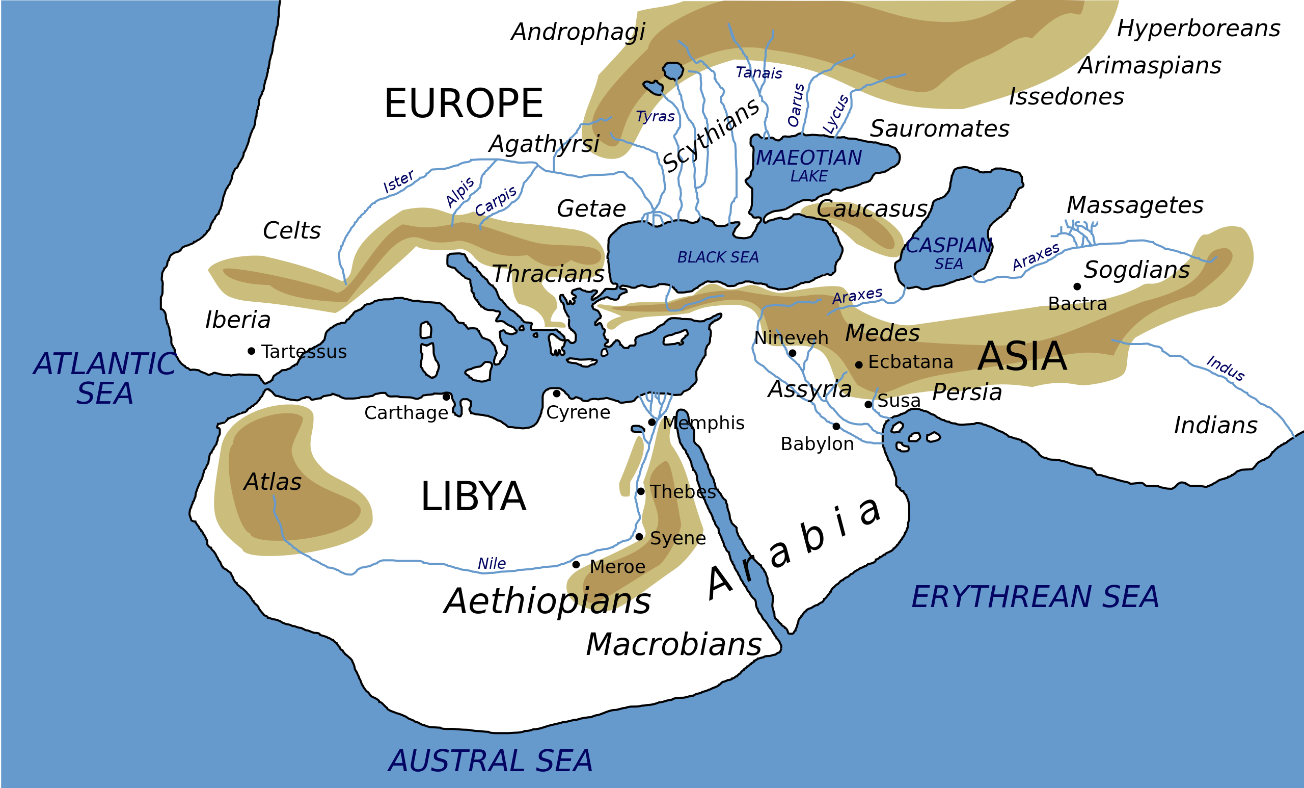
Català: Mapa del món segons Heròdot, segle V a. C. Deutsch: Mögliche Weltdarstellung nach den Historien des Herodot (5. Jahrhundert v. Chr) English: Possibly what the world according to Herodotus looked like (5th century BC). Español: Mapa del mundo según Heródoto, siglo V a. C. Euskara: Munduaren balizko mapa Herodotoren arabera, K. a. V. mendean Français : Reconstruction du monde décrit par Hérodote dans son Enquête (Ve siècle av. J.-C.). Hrvatski: Rekonstruirana karta svijeta prema Herodotu (5. st. pr. Kr.) Italiano: Carta Geografica da Herodotus Ελληνικά: Χάρτης της Οικουμένης κατά τον Ηρόδοτο, τον 5 αιώνα π. Χ. ქართული: ჰეროდოტეს მსოფლიოს რუკა ქართულად ) ไทย: แผนที่โลกที่ใกล้เคียงตามคำกล่าวของเฮอรอโดทัสมากที่สุด (ศตวรรษที่ 5 ก่อนคริสตกาล) 中文: 希罗多德笔下的世界,译名主要依照《历史》(徐松岩译) 注:唯极南的Macrobian人未能在英文维基百科中提到的3.114的英汉译本对应位置找到,只提到了埃塞俄比亚地区的人是人类中身材最为高大的,且条目中提及的防腐技术、寿命等描述也在书中对应埃塞俄比亚人。 العربية : خارطة العالم كما يُحتمل أن تصوره هيرودوت خلال القرن الخامس ق.م.. کوردی: نەخشەی جیھان بەو شێوەیەی کە ھیرۆدیۆت پێشبینی کردووە لە ( قەرنی پێنج پێش میلاد |
||
| Päiväys | |||
| Lähde | Own work (based on the GIF by Marco Prins and Jona Lendering from www.livius.org, from http://www.mediterranees.net/geographie/herodote/cartes.html, http://www.henry-davis.com/MAPS/Ancientimages/109A.GIF). Compare this map from The Challenger Reports, 1895. | ||
| Tekijä | |||
| Käyttöoikeus (Tämän tiedoston uudelleenkäyttö) |
|
||
| Georeferointi | If inappropriate please set warp_status = skip to hide. | ||
| Muut versiot |
Tämän tiedoston johdannaisteoksia: []
|


|
Tässä SVG-tiedostossa on tekstiä, jonka voi kääntää helposti suomen kielelle käyttäen SVG-editoria kuten Inkscapea tai Adobe Illustratoria. Lisätietoja on sivulla Commons:Translation possible/Learn more. Voit myös ladata ja tallentaa sen, ja kääntää sen manuaalisesti tekstimuokkaimella. |
Tiedoston historia
Päiväystä napsauttamalla näet, millainen tiedosto oli kyseisellä hetkellä.
| Päiväys | Pienoiskuva | Koko | Käyttäjä | Kommentti | |
|---|---|---|---|---|---|
| nykyinen | 8. helmikuuta 2024 kello 04.59 | | 788 × 476 (319 KiB) | Manlleus | File uploaded using svgtranslate tool (https://svgtranslate.toolforge.org/). Added translation for ca. |
| 3. tammikuuta 2023 kello 21.32 |  | 788 × 476 (325 KiB) | Chiswick Chap | scale a couple of key labels | |
| 4. huhtikuuta 2022 kello 13.37 |  | 788 × 476 (315 KiB) | Shapez | Reverted to version as of 08:42, 4 February 2022 (UTC) | |
| 3. huhtikuuta 2022 kello 20.23 |  | 788 × 476 (341 KiB) | Shapez | File uploaded using svgtranslate tool (https://svgtranslate.toolforge.org/). Added translation for ja. | |
| 4. helmikuuta 2022 kello 11.42 |  | 788 × 476 (315 KiB) | Andrei Stroe | File uploaded using svgtranslate tool (https://svgtranslate.toolforge.org/). Added translation for ro. | |
| 16. toukokuuta 2018 kello 20.45 |  | 788 × 476 (277 KiB) | AnonMoos | Changed "Niniveh" to more usual spellling "Nineveh" | |
| 15. marraskuuta 2010 kello 12.54 |  | 788 × 476 (277 KiB) | Bibi Saint-Pol | Reverted to version as of 04:19, 15 December 2006: this is Russian, not English | |
| 15. marraskuuta 2010 kello 01.23 |  | 788 × 476 (277 KiB) | McSery | {{Information |Description= {{en|Possibly what the world according to Herodotus looked like (5th century BC).}} |Source=Own work (based on the GIF by Marco Prins and Jona Lendering from www.livius.org, see http://www.livius.org/a/1/maps/ | |
| 15. joulukuuta 2006 kello 07.19 |  | 788 × 476 (277 KiB) | Bibi Saint-Pol | doublon Memphis | |
| 15. joulukuuta 2006 kello 05.18 |  | 788 × 476 (277 KiB) | Bibi Saint-Pol | {{Inkscape}} {{Information |Description= {{en|Possibly what the map of the world by Herodotus looked like (5th century BC).}} |Source=Own work (based on the GIF by Marco Prins and Jona Lendering from www.livius.org, see http://www.livius |
Tiedoston käyttö
Tiedoston järjestelmänlaajuinen käyttö
Seuraavat muut wikit käyttävät tätä tiedostoa:
- Käyttö kohteessa af.wikipedia.org
- Käyttö kohteessa azb.wikipedia.org
- Käyttö kohteessa bg.wikipedia.org
- Käyttö kohteessa bn.wikipedia.org
- Käyttö kohteessa ca.wikipedia.org
- Käyttö kohteessa cdo.wikipedia.org
- Käyttö kohteessa ceb.wikipedia.org
- Käyttö kohteessa ckb.wikipedia.org
- Käyttö kohteessa cs.wikipedia.org
- Käyttö kohteessa en.wikipedia.org
- Andromeda (mythology)
- Atlantis
- Celts
- Nile
- Generations of Noah
- Dacians
- Libya of Egypt
- Histories (Herodotus)
- Names for India
- Ecumene
- Scylax of Caryanda
- Issedones
- Ancient Libya
- Aethiopia
- List of Graeco-Roman geographers
- Dzungarian Gate
- Macrobians
- User talk:User0512
- User talk:User0510
- Achaemenid conquest of the Indus Valley
- India (Herodotus)
- List of ancient great powers
- Black people in ancient Roman history
- Talk:Eurasia/Archive 1
- User:Falcaorib
- Tovsta Mohyla
- Ancient Africa
- Käyttö kohteessa en.wikiquote.org
- Käyttö kohteessa en.wikiversity.org
- Käyttö kohteessa fa.wikipedia.org
- Käyttö kohteessa gl.wikipedia.org
- Käyttö kohteessa he.wikipedia.org
- Käyttö kohteessa hy.wikipedia.org
- Käyttö kohteessa id.wikipedia.org
Näytä lisää tämän tiedoston järjestelmänlaajuista käyttöä.