Tiedosto:Equatorial Guinea, administrative divisions - de - colored 2020.svg

Alkuperäinen tiedosto (SVG-tiedosto; oletustarkkuus 1 091 × 1 042 kuvapistettä; tiedostokoko 194 KiB)
| Tämä tiedosto on tiedostotietokanta Wikimedia Commonsista. Tiedot kuvaussivulta näkyvät alla. |  |
Tiedoston kuvaussivu Commonsissa |
Yhteenveto


.svg)


_(Paris_zoom).svg)
.svg)
,_administrative_divisions_-_de_-_colored_(multizoom).svg)
_-_colored.svg)
.svg)
,_administrative_divisions_-_Nmbrs_(multizoom).svg)
,_administrative_divisions_-_de_-_colored.svg)
_-_de_-_colored.svg)

.svg)

.svg)
Lisenssi
Usage of this file with:

explanatory notes: Legally binding is only the full legalcode. For a free usage I recommend to respect the following licence conditions:
1. Provide my name as given above: NordNordWest,
2. a copy of, or the URI for, the applicable license: https://creativecommons.org/licenses/by-sa/3.0/de/legalcode,
3. the title of the work,
4. in the case of an adaptation, a credit identifying the use of the work in the adaptation.
This license and the rights granted hereunder will terminate automatically upon any breach by you of the terms of this license. Any of the above conditions can be waived if you get permission from the copyright holder. If you have questions or wish differing conditions, please contact me through nnwest or my discussion page ![]() t-online.de
t-online.de
- Voit:
- jakaa – kopioida, levittää ja esittää teosta
- remiksata – valmistaa muutettuja teoksia
- Seuraavilla ehdoilla:
- nimeäminen – Sinun on mainittava lähde asianmukaisesti, tarjottava linkki lisenssiin sekä merkittävä, mikäli olet tehnyt muutoksia. Voit tehdä yllä olevan millä tahansa kohtuullisella tavalla, mutta et siten, että annat ymmärtää lisenssinantajan suosittelevan sinua tai teoksen käyttöäsi.
- jaa samoin – Jos muutat tai perustat tähän työhön, voit jakaa tuloksena syntyvää työtä vain tällä tai tämän kaltaisella lisenssillä.

Tiedoston historia
Päiväystä napsauttamalla näet, millainen tiedosto oli kyseisellä hetkellä.
| Päiväys | Pienoiskuva | Koko | Käyttäjä | Kommentti | |
|---|---|---|---|---|---|
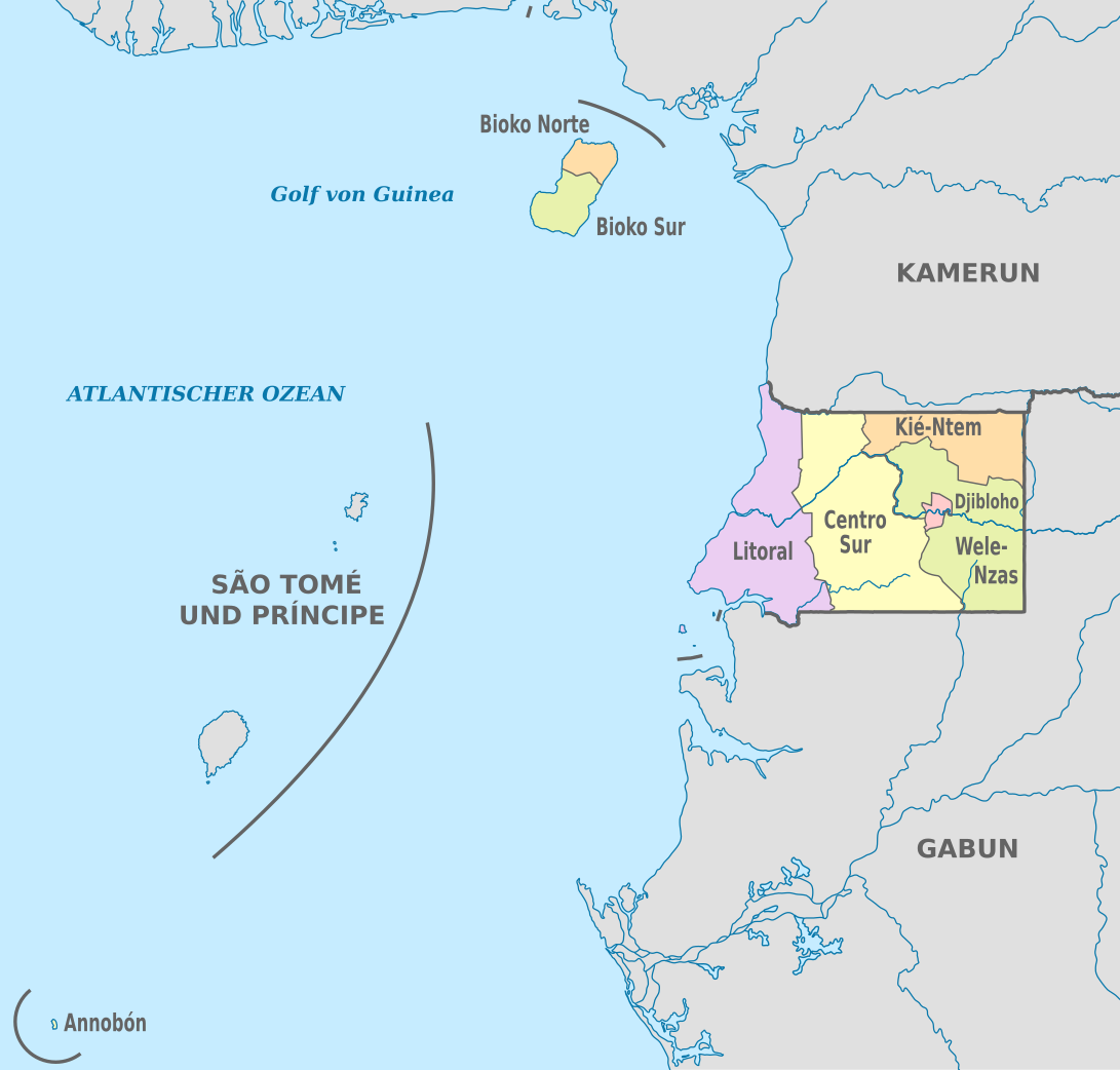
| nykyinen | 25. marraskuuta 2020 kello 22.53 | | 1 091 × 1 042 (194 KiB) | NordNordWest | == {{int:filedesc}} == {{Information |Description={{de|Karte der politischen Gliederung von Äquatorialguinea, Stand 2020}} {{en|Map of the administrative divisions of Equatorial Guinee}} |Source={{own}} |date=2020-11-25 |author={{U|NordNordWest}} |permission= |other_versions={{SVG labeled maps of administrative divisions (location map scheme)}} }} == {{int:license-header}} == {{User:NordNordWest/LicenceMap}} [[Category:SVG labeled maps of administrative divisions of Equatorial Guinea (locat... |
Tiedoston käyttö
Seuraava sivu käyttää tätä tiedostoa:
Tiedoston järjestelmänlaajuinen käyttö
Seuraavat muut wikit käyttävät tätä tiedostoa:
- Käyttö kohteessa ab.wikipedia.org
- Käyttö kohteessa ca.wikipedia.org
- Käyttö kohteessa cs.wikipedia.org
- Käyttö kohteessa de.wikipedia.org
- Käyttö kohteessa en.wikipedia.org
- Käyttö kohteessa eo.wikipedia.org
- Käyttö kohteessa frr.wikipedia.org
- Käyttö kohteessa gl.wikipedia.org
- Käyttö kohteessa id.wikipedia.org
- Käyttö kohteessa is.wikipedia.org
- Käyttö kohteessa it.wikipedia.org
- Käyttö kohteessa ja.wikipedia.org
- Käyttö kohteessa lv.wikipedia.org
- Käyttö kohteessa nl.wikipedia.org
- Käyttö kohteessa ru.wikipedia.org
- Käyttö kohteessa tr.wikipedia.org
- Käyttö kohteessa zh.wikipedia.org