Tiedosto:East of England counties 2009 map.svg
Siirry navigaatioon
Siirry hakuun

Tämän PNG-esikatselun koko koskien SVG-tiedostoa: 573 × 600 kuvapistettä. Muut resoluutiot: 229 × 240 kuvapistettä | 459 × 480 kuvapistettä | 734 × 768 kuvapistettä | 979 × 1 024 kuvapistettä | 1 957 × 2 048 kuvapistettä | 1 210 × 1 266 kuvapistettä.
Alkuperäinen tiedosto (SVG-tiedosto; oletustarkkuus 1 210 × 1 266 kuvapistettä; tiedostokoko 2,2 MiB)
| Tämä tiedosto on tiedostotietokanta Wikimedia Commonsista. Tiedot kuvaussivulta näkyvät alla. |  |
Tiedoston kuvaussivu Commonsissa |
Yhteenveto
| Kuvaus |
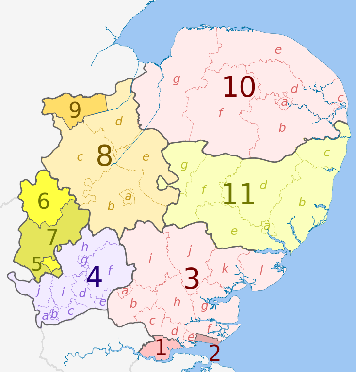
English: Map of the East of England region, showing its counties and administrative districts in 2009. The county colours are the same as those in File:English metropolitan and non-metropolitan counties 2009.svg.
For the districts since 1 April 2019, see File:East of England counties 2019 map.svg Equirectangular map projection on WGS 84 datum, with N/S stretched 160% Geographic limits:
|
| Päiväys | (UTC) |
| Lähde |
Tämä tiedosto on johdettu tiedostosta: |
| Tekijä |
|
| Muut versiot | File:East of England counties 2019 map.svg – version since 1 April 2019 |


| Map | Ceremonial county | Shire county / unitary | Districts |
|---|---|---|---|
 |
Essex | 1. Thurrock U.A. | |
| 2. Southend-on-Sea U.A. | |||
| 3. Essex | a) Harlow, b) Epping Forest, c) Brentwood, d) Basildon, e) Castle Point, f) Rochford, g) Maldon, h) Chelmsford, i) Uttlesford, j) Braintree, k) Colchester, l) Tendring | ||
| 4. Hertfordshire | a) Three Rivers, b) Watford, c) Hertsmere, d) Welwyn Hatfield, e) Broxbourne, f) East Hertfordshire, g) Stevenage, h) North Hertfordshire, i) St Albans, j) Dacorum | ||
| Bedfordshire | 5. Luton U.A. | ||
| 6. Bedford U.A. | |||
| 7. Central Bedfordshire U.A. | |||
| Cambridgeshire | 8. Cambridgeshire | a) Cambridge, b) South Cambridgeshire, c) Huntingdonshire, d) Fenland, e) East Cambridgeshire | |
| 9. Peterborough U.A. | |||
| 10. Norfolk | a) Norwich, b) South Norfolk, c) Great Yarmouth, d) Broadland, e) North Norfolk, f) Breckland, g) King's Lynn and West Norfolk | ||
| 11. Suffolk | a) Ipswich, b) Suffolk Coastal, c) Waveney, d) Mid Suffolk, e) Babergh, f) St. Edmundsbury, g) Forest Heath | ||
Lisenssi
Tämä tiedosto on lisensoitu Creative Commons Nimeä-JaaSamoin 3.0 Ei sovitettu -lisenssillä.
Nimeä: Dr Greg and Nilfanion. Contains Ordnance Survey data © Crown copyright and database right 2010
- Voit:
- jakaa – kopioida, levittää ja esittää teosta
- remiksata – valmistaa muutettuja teoksia
- Seuraavilla ehdoilla:
- nimeäminen – Sinun on mainittava lähde asianmukaisesti, tarjottava linkki lisenssiin sekä merkittävä, mikäli olet tehnyt muutoksia. Voit tehdä yllä olevan millä tahansa kohtuullisella tavalla, mutta et siten, että annat ymmärtää lisenssinantajan suosittelevan sinua tai teoksen käyttöäsi.
- jaa samoin – Jos muutat tai perustat tähän työhön, voit jakaa tuloksena syntyvää työtä vain tällä tai tämän kaltaisella lisenssillä.
Alkuperäinen tallennusloki
This image is a derivative work of the following images:
- File:East_Midlands_districts_2011_map.svg licensed with Cc-by-sa-3.0, GFDL
- 2011-05-01T18:55:02Z Nilfanion 1099x1305 (1687648 Bytes) == Summary == {{Information |Description=Map of the [[w:East Midlands|East Midlands]] region showing the administrative districts. Equirectangular map projection on WGS 84 datum, with N/S stretched 165% Geographic limits: *
- File:English_ceremonial_counties_2010.svg licensed with Cc-by-sa-3.0, GFDL
- 2010-11-23T16:39:55Z Nilfanion 1108x1345 (308868 Bytes) thicker lines
- 2010-11-23T16:20:19Z Nilfanion 1108x1345 (301520 Bytes) tweaks
- 2010-10-26T20:34:20Z Nilfanion 817x990 (1391832 Bytes) {{Information |Description=Map showing the [[w:ceremonial counties of England]] including the City of London, in 2010. Equirectangular map projection on WGS 84 datum, with N/S stretched 170% Geographic limits: *West: 6.75W
Uploaded with derivativeFX
Tiedoston historia
Päiväystä napsauttamalla näet, millainen tiedosto oli kyseisellä hetkellä.
| Päiväys | Pienoiskuva | Koko | Käyttäjä | Kommentti | |
|---|---|---|---|---|---|
| nykyinen | 1. toukokuuta 2012 kello 00.06 | | 1 210 × 1 266 (2,2 MiB) | Dr Greg | == {{int:filedesc}} == {{Information |Description={{en|Map of the East Midlands region of England, showing its counties and administrative districts. The county colours are the same as those in [[:File:English metropolitan and non-m... |
Tiedoston käyttö
Seuraava sivu käyttää tätä tiedostoa:
Tiedoston järjestelmänlaajuinen käyttö
Seuraavat muut wikit käyttävät tätä tiedostoa:
- Käyttö kohteessa ar.wikipedia.org
- Käyttö kohteessa fa.wikipedia.org
- Käyttö kohteessa frr.wikipedia.org
- Käyttö kohteessa fr.wikipedia.org
- Käyttö kohteessa fy.wikipedia.org
- Käyttö kohteessa hu.wikipedia.org
- Käyttö kohteessa mr.wikipedia.org
- Käyttö kohteessa pt.wikipedia.org
- Käyttö kohteessa tr.wikipedia.org
- Käyttö kohteessa vi.wikipedia.org
- Käyttö kohteessa vls.wikipedia.org
- Käyttö kohteessa zh-yue.wikipedia.org