Tiedosto:Cayman Islands UN map June 2016-de.svg

Alkuperäinen tiedosto (SVG-tiedosto; oletustarkkuus 903 × 671 kuvapistettä; tiedostokoko 2,34 MiB)
| Tämä tiedosto on tiedostotietokanta Wikimedia Commonsista. Tiedot kuvaussivulta näkyvät alla. |  |
Tiedoston kuvaussivu Commonsissa |
Yhteenveto
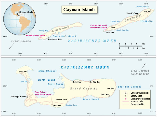
| Kuvaus |
Deutsch: Karte der Cayman Islands (Juni 2016).
English: Map of Cayman Islands (June 2016). |
|||
| Päiväys | ||||
| Lähde | UN Cartographic Section | |||
| Tekijä | Furfur | |||
| Käyttöoikeus (Tämän tiedoston uudelleenkäyttö) |
|
|||
| SVG kehittely | Tämä vektorigrafiikkatiedosto luotiin käyttäen apuna ohjelmaa Adobe Illustrator |

Tiedoston historia
Päiväystä napsauttamalla näet, millainen tiedosto oli kyseisellä hetkellä.
| Päiväys | Pienoiskuva | Koko | Käyttäjä | Kommentti | |
|---|---|---|---|---|---|
| nykyinen | 14. lokakuuta 2018 kello 17.00 | | 903 × 671 (2,34 MiB) | Furfur | Kosmetik |
| 14. lokakuuta 2018 kello 16.42 |  | 903 × 671 (2,34 MiB) | Furfur | == {{int:filedesc}} == {{Information |Description={{User:Medium69/Traduction}} {{de|1=Karte der ''Cayman Islands'' (Juni 2016).}} {{en|1=Map of Cayman Islands (June 2016).}} |Source=UN Cartographic Section |Date=2018-10-14 |Author={{U|Furfur}} |Permission={{UN map}} |Other versions= |Other fields={{Igen|A|+|%|s=m}} }} Category:SVG maps of the Caribbean Category:Maps of the Cayman Islands Category:SVG maps in German |
Tiedoston käyttö
Seuraava sivu käyttää tätä tiedostoa:
Tiedoston järjestelmänlaajuinen käyttö
Seuraavat muut wikit käyttävät tätä tiedostoa:
- Käyttö kohteessa de.wikipedia.org