Tiedosto:Canada Manitoba location map 2.svg
Siirry navigaatioon
Siirry hakuun

Tämän PNG-esikatselun koko koskien SVG-tiedostoa: 486 × 599 kuvapistettä. Muut resoluutiot: 195 × 240 kuvapistettä | 389 × 480 kuvapistettä | 623 × 768 kuvapistettä | 831 × 1 024 kuvapistettä | 1 661 × 2 048 kuvapistettä | 1 512 × 1 864 kuvapistettä.
Alkuperäinen tiedosto (SVG-tiedosto; oletustarkkuus 1 512 × 1 864 kuvapistettä; tiedostokoko 599 KiB)
| Tämä tiedosto on tiedostotietokanta Wikimedia Commonsista. Tiedot kuvaussivulta näkyvät alla. |  |
Tiedoston kuvaussivu Commonsissa |
Yhteenveto
| Kuvaus |
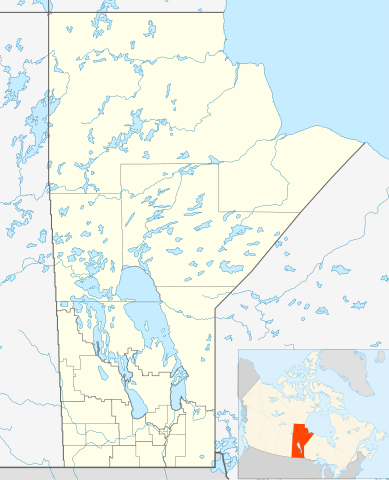
Quadratische Plattkarte, N-S-Streckung 170 %. Geographische Begrenzung der Karte:
Equirectangular projection, N/S stretching 170 %. Geographic limits of the map:
|
| Päiväys | |
| Lähde | Oma teos, File:Canada_Manitoba_location_map.svg by NordNordWest |
| Tekijä | Hanhil 17:29, 24 September 2009 (UTC) |
| Käyttöoikeus (Tämän tiedoston uudelleenkäyttö) |
Minä, tämän teoksen tekijänoikeuksien haltija, julkaisen täten tämän teoksen seuraavalla lisenssillä: Tämä tiedosto on lisensoitu Creative Commons Nimeä-JaaSamoin 3.0 Ei sovitettu -lisenssillä.
|
| SVG kehittely | Tämä vektorigrafiikkatiedosto luotiin käyttäen apuna ohjelmaa Inkscape |
Tiedoston historia
Päiväystä napsauttamalla näet, millainen tiedosto oli kyseisellä hetkellä.
| Päiväys | Pienoiskuva | Koko | Käyttäjä | Kommentti | |
|---|---|---|---|---|---|
| nykyinen | 3. helmikuuta 2019 kello 10.31 | | 1 512 × 1 864 (599 KiB) | JoKalliauer | valid id-names |
| 24. syyskuuta 2009 kello 20.29 |  | 1 512 × 1 864 (906 KiB) | Hanhil | {{Information |Description= {{de|Positionskarte von Manitoba, Kanada}} Quadratische Plattkarte, N-S-Streckung 170 %. Geographische Begrenzung der Karte: * N: 60.3° N * S: 48.7° N * W: 104.0° W * O: 88.0° W {{en|Location |
Tiedoston käyttö
Seuraavat 22 sivua käyttävät tätä tiedostoa:
- Brandon (Manitoba)
- Carman (Manitoba)
- Churchill (Kanada)
- Flin Flon
- Gimli (Manitoba)
- Glenboro
- Grand Rapids (Kanada)
- Gypsumville
- Lynn Lake
- Morden (Manitoba)
- Pilot Mound (Kanada)
- Portage la Prairie
- Riverton (Manitoba)
- Selkirk (kaupunki)
- Springfield (Manitoba)
- St. Andrews (Manitoba)
- Steinbach
- West St. Paul (Kanada)
- Winkler
- Winnipeg
- Winnipeg Beach
- Malline:Sijaintikartta Kanada Manitoba
Tiedoston järjestelmänlaajuinen käyttö
Seuraavat muut wikit käyttävät tätä tiedostoa:
- Käyttö kohteessa ar.wikipedia.org
- Käyttö kohteessa azb.wikipedia.org
- Käyttö kohteessa ba.wikipedia.org
- Käyttö kohteessa bg.wikipedia.org
- Käyttö kohteessa ca.wikipedia.org
- Käyttö kohteessa ceb.wikipedia.org
- Käyttö kohteessa en.wikipedia.org
- Gilbert Plains
- Neelin
- Cree
- The Pas
- Fort Garry
- Brandon, Manitoba
- Flin Flon
- Churchill, Manitoba
- Grunthal, Manitoba
- Lynn Lake
- International Peace Garden
- Birtle, Manitoba
- Portage la Prairie
- Dauphin, Manitoba
- Roblin, Manitoba
- Dominion City
- Manitou, Manitoba
- Forrest, Manitoba
- Thompson, Manitoba
- Steinbach, Manitoba
- Lower Fort Garry
- Deloraine, Manitoba
- Winnipegosis
- Sainte Rose du Lac
- Gunton, Manitoba
- Pisew Falls Provincial Park
- Hamiota, Manitoba
- CFB Shilo
- Winkler, Manitoba
- Boissevain, Manitoba
- Cranberry Portage
- Selkirk, Manitoba
- Morden, Manitoba
- Clearwater, Manitoba
- Souris, Manitoba
- Niverville, Manitoba
- Bakers Narrows
- Dugald, Manitoba
- Swan River, Manitoba
Näytä lisää tämän tiedoston järjestelmänlaajuista käyttöä.