Tiedosto:Antarctic expedition map (Amundsen - Scott)-en.svg
Siirry navigaatioon
Siirry hakuun

Tämän PNG-esikatselun koko koskien SVG-tiedostoa: 610 × 599 kuvapistettä. Muut resoluutiot: 244 × 240 kuvapistettä | 489 × 480 kuvapistettä | 782 × 768 kuvapistettä | 1 042 × 1 024 kuvapistettä | 2 084 × 2 048 kuvapistettä | 1 898 × 1 865 kuvapistettä.
Alkuperäinen tiedosto (SVG-tiedosto; oletustarkkuus 1 898 × 1 865 kuvapistettä; tiedostokoko 304 KiB)
| Tämä tiedosto on tiedostotietokanta Wikimedia Commonsista. Tiedot kuvaussivulta näkyvät alla. | -en.svg?uselang=fi) |
Tiedoston kuvaussivu Commonsissa |
Yhteenveto
| Kuvaus |
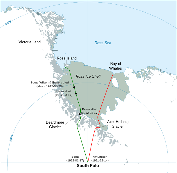
English: Map showing the polar journeys of the Scott's Terra Nova expedition (green) and Amundsen's expedition (red) to reach the South Pole
Français : Carte montrant les parcours de l'expédition Terra Nova de Scott (vert) et celle d'Amundsen (rouge) pour atteindre le Pôle Sud
Español: Mapa mostrando las travesías polares de la expedición Terra Nova de Scott (verde) y la expedición de Amundsen (rojo) para alcanzar el Polo Sur. |
| Päiväys | |
| Lähde |
Own work using:
|
| Tekijä | Shakki |
| Muut versiot |
[]
|
-ar.svg)
-bg.svg)
-ca.svg)
-cs.svg)
-cs-colorswap.svg)
-de.svg)
-el.svg)
-en.svg)
-es.svg)
-fr.svg)
-ka.svg)
-no.svg)
-ru.svg)
-he.svg)
-zh-hans.svg)
-zh-hant.svg)
Lisenssi
| Minä, tämän teoksen tekijänoikeudellinen omistaja, julkaisen tämän teoksen public domainiin eli luovun kaikista tekijänoikeuksista lain sallimissa puitteissa. Tämä on voimassa maailmanlaajuisesti. Joissain maissa laki ei mahdollista tätä. Mikäli näin on: Myönnän kenelle tahansa oikeuden käyttää tätä teosta mihin tahansa tarkoitukseen, ilman mitään ehtoja, ellei laki vaadi ehtojen asettamista. |
| Annotations | This image is annotated: View the annotations at Commons |
-en.svg)
Tiedoston historia
Päiväystä napsauttamalla näet, millainen tiedosto oli kyseisellä hetkellä.
| Päiväys | Pienoiskuva | Koko | Käyttäjä | Kommentti | |
|---|---|---|---|---|---|
| nykyinen | 29. huhtikuuta 2023 kello 06.30 | | 1 898 × 1 865 (304 KiB) | Pimms1 | Changed dates to YYYY-MM-DD format |
| 7. maaliskuuta 2010 kello 00.15 |  | 1 898 × 1 865 (306 KiB) | S.L. | revert | |
| 7. maaliskuuta 2010 kello 00.13 |  | 400 × 512 (2,79 MiB) | S.L. | better version, mistakes fixed | |
| 17. maaliskuuta 2008 kello 21.44 |  | 1 898 × 1 865 (306 KiB) | Shakki | {{Information |Description={{en|Map showing the polar journeys of the Scott's ''Terra Nova'' expedition (green) and Amundsen's expedition (red) to reach the South Pole}} {{fr|Carte montrant les parcours de l'expédition ''Terra Nova'' de Scott (vert) et c |
Tiedoston käyttö
Seuraavat 2 sivua käyttävät tätä tiedostoa:
Tiedoston järjestelmänlaajuinen käyttö
Seuraavat muut wikit käyttävät tätä tiedostoa:
- Käyttö kohteessa ar.wikipedia.org
- Käyttö kohteessa az.wikipedia.org
- Käyttö kohteessa el.wikipedia.org
- Käyttö kohteessa en.wikipedia.org
- Käyttö kohteessa en.wikivoyage.org
- Käyttö kohteessa es.wikipedia.org
- Käyttö kohteessa eu.wikipedia.org
- Käyttö kohteessa fa.wikipedia.org
- Käyttö kohteessa hu.wikipedia.org
- Käyttö kohteessa ja.wikipedia.org
- Käyttö kohteessa la.wikipedia.org
- Käyttö kohteessa mk.wikipedia.org
- Käyttö kohteessa nl.wikipedia.org
- Käyttö kohteessa pl.wikipedia.org
- Käyttö kohteessa pt.wikipedia.org
- Käyttö kohteessa ro.wikipedia.org
- Käyttö kohteessa simple.wikipedia.org
- Käyttö kohteessa zh.wikipedia.org
-en.svg)