Tiedosto:Aerial view of the Central Intelligence Agency headquarters, Langley, Virginia - Corrected and Cropped.jpg
Siirry navigaatioon
Siirry hakuun
Tämän esikatselun koko: 800 × 356 kuvapistettä. Muut resoluutiot: 320 × 142 kuvapistettä | 640 × 284 kuvapistettä | 1 024 × 455 kuvapistettä | 1 280 × 569 kuvapistettä | 2 560 × 1 138 kuvapistettä | 5 523 × 2 455 kuvapistettä.
Alkuperäinen tiedosto (5 523 × 2 455 kuvapistettä, 7,57 MiB, MIME-tyyppi: image/jpeg)
| Tämä tiedosto on tiedostotietokanta Wikimedia Commonsista. Tiedot kuvaussivulta näkyvät alla. |  |
Tiedoston kuvaussivu Commonsissa |
Yhteenveto
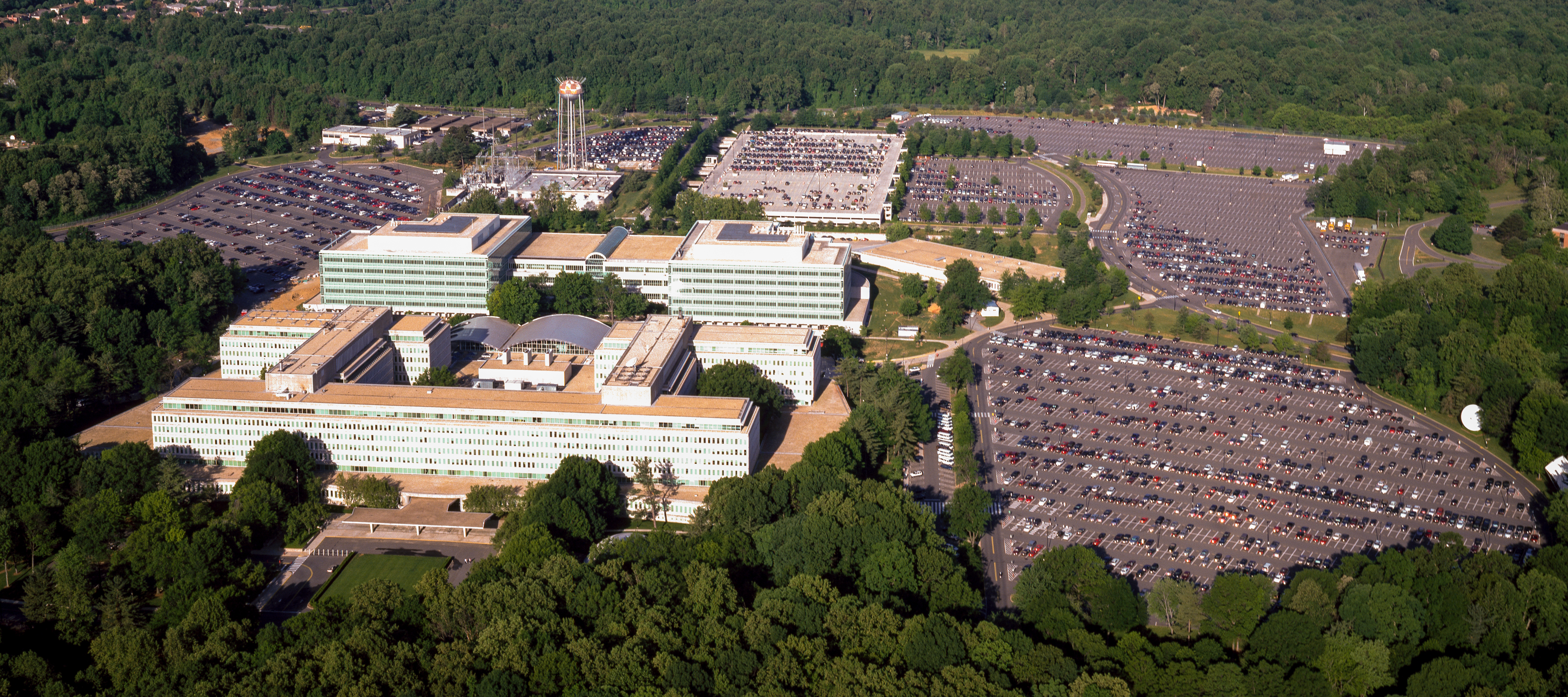
| Aerial view of the Central Intelligence Agency headquarters, Langley, Virginia
( |
|||||||||||||||||||||||||||
|---|---|---|---|---|---|---|---|---|---|---|---|---|---|---|---|---|---|---|---|---|---|---|---|---|---|---|---|
| Tekijä |
|
||||||||||||||||||||||||||
| Otsikko |
Aerial view of the Central Intelligence Agency headquarters, Langley, Virginia |
||||||||||||||||||||||||||
| Kuvan esittämä paikka | Central Intelligence Agency headquarters | ||||||||||||||||||||||||||
| Päiväys | vuosien 1980 ja 2006 välisenä aikana | ||||||||||||||||||||||||||
| Tekniikka | 1 transparency : color | ||||||||||||||||||||||||||
| Mitat | 4 x 5 in. or smaller. | ||||||||||||||||||||||||||
| Kokoelma |
|
||||||||||||||||||||||||||
| Nykyinen sijainti |
Prints and Photographs Division http://hdl.loc.gov/loc.pnp/pp.print |
||||||||||||||||||||||||||
| Lisätietoja |
|
||||||||||||||||||||||||||
| Lähde |
|
||||||||||||||||||||||||||
| Käyttöoikeus (Tämän tiedoston uudelleenkäyttö) |
Rights Advisory: No known restrictions on publication. | ||||||||||||||||||||||||||
| Muut versiot |
|
||||||||||||||||||||||||||


| | Tämä ja muut kuvat kartalla: OpenStreetMap |
Lisenssi
| This work is from the Carol M. Highsmith Archive collection at the Library of Congress. According to the library, there are no known copyright restrictions on the use of this work. Carol M. Highsmith has stipulated that her photographs are in the public domain. Photographs of sculpture or other works of art may be restricted by the copyright of the artist. |
 |
Tiedoston historia
Päiväystä napsauttamalla näet, millainen tiedosto oli kyseisellä hetkellä.
| Päiväys | Pienoiskuva | Koko | Käyttäjä | Kommentti | |
|---|---|---|---|---|---|
| nykyinen | 22. huhtikuuta 2017 kello 19.17 | | 5 523 × 2 455 (7,57 MiB) | Falcorian | User created page with UploadWizard |
Tiedoston käyttö
Seuraavat 3 sivua käyttävät tätä tiedostoa:
Tiedoston järjestelmänlaajuinen käyttö
Seuraavat muut wikit käyttävät tätä tiedostoa:
- Käyttö kohteessa ar.wikipedia.org
- Käyttö kohteessa arz.wikipedia.org
- Käyttö kohteessa ast.wikipedia.org
- Käyttö kohteessa azb.wikipedia.org
- Käyttö kohteessa az.wikipedia.org
- Käyttö kohteessa br.wikipedia.org
- Käyttö kohteessa ca.wikipedia.org
- Käyttö kohteessa ce.wikipedia.org
- Käyttö kohteessa cs.wikipedia.org
- Käyttö kohteessa cy.wikipedia.org
- Käyttö kohteessa da.wikipedia.org
- Käyttö kohteessa de.wikipedia.org
- Käyttö kohteessa en.wikipedia.org
- Käyttö kohteessa eo.wikipedia.org
- Käyttö kohteessa eo.wikiquote.org
- Käyttö kohteessa es.wikipedia.org
- Käyttö kohteessa fr.wikipedia.org
- Käyttö kohteessa fr.wikinews.org
- Käyttö kohteessa ga.wikipedia.org
- Käyttö kohteessa ha.wikipedia.org
- Käyttö kohteessa he.wikipedia.org
- Käyttö kohteessa hu.wikipedia.org
- Käyttö kohteessa id.wikipedia.org
- Käyttö kohteessa it.wikipedia.org
- Käyttö kohteessa ja.wikipedia.org
- Käyttö kohteessa ko.wikipedia.org
- Käyttö kohteessa ky.wikipedia.org
- Käyttö kohteessa lt.wikipedia.org
- Käyttö kohteessa lv.wikipedia.org
- Käyttö kohteessa mn.wikipedia.org
- Käyttö kohteessa ne.wikipedia.org
- Käyttö kohteessa nn.wikipedia.org
- Käyttö kohteessa no.wikipedia.org
- Käyttö kohteessa ro.wikipedia.org
- Käyttö kohteessa ru.wikipedia.org
- Käyttö kohteessa ru.wikinews.org
- Käyttö kohteessa sk.wikipedia.org
- Käyttö kohteessa sl.wikipedia.org
- Käyttö kohteessa sr.wikipedia.org
Näytä lisää tämän tiedoston järjestelmänlaajuista käyttöä.