Tiedosto:Aegean Sea map bathymetry-fi.svg
Siirry navigaatioon
Siirry hakuun

Tämän PNG-esikatselun koko koskien SVG-tiedostoa: 493 × 599 kuvapistettä. Muut resoluutiot: 197 × 240 kuvapistettä | 395 × 480 kuvapistettä | 631 × 768 kuvapistettä | 842 × 1 024 kuvapistettä | 1 684 × 2 048 kuvapistettä | 3 750 × 4 560 kuvapistettä.
Alkuperäinen tiedosto (SVG-tiedosto; oletustarkkuus 3 750 × 4 560 kuvapistettä; tiedostokoko 3,52 MiB)
| Tämä tiedosto on tiedostotietokanta Wikimedia Commonsista. Tiedot kuvaussivulta näkyvät alla. |  |
Tiedoston kuvaussivu Commonsissa |
Yhteenveto
| Kuvaus |
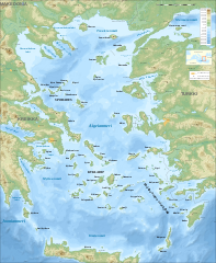
English: Bathymetric map in Finnish of the Aegean Sea, Mediterranean Sea.
Note: The background map is a raster image embedded in the SVG file. Français : Carte bathymétrique en finlandais de la Mer Égée, Mer Méditerranée.
Note : Le fond de carte est une image bitmap embarquée dans le fichier SVG.
|
| Päiväys | marraskuu 2007 (modified September 2008) |
| Lähde |
Oma teos (Original text: Own work ;)
|
| Tekijä | Eric Gaba (Sting - fr:Sting), translated by QWerk |
| Käyttöoikeus (Tämän tiedoston uudelleenkäyttö) |
Attribution and Share-Alike required |
| Muut versiot |
[]
Same map but full SVG and without relief and bathymetry:
|
| SVG kehittely |


Lisenssi
Eric Gaba, tämän teoksen tekijänoikeuksien haltija, julkaisee täten tämän teoksen seuraavilla lisensseillä:

|
Voit kopioida, levittää ja/tai muuttaa tätä asiakirjaa GNU Free Documentation License -lisenssin version 1.2 tai minkä tahansa Free Software Foundationin julkaiseman myöhemmän version ehtojen alaisena; ei koske muuttumattomia kohtia, etukannen tekstejä eikä takakannen tekstejä. Kopio tästä lisenssistä on saatavilla osiossa GNU Free Documentation License. |
This file is licensed under the Creative Commons Attribution-Share Alike 4.0 International, 3.0 Unported, 2.5 Generic, 2.0 Generic and 1.0 Generic license.
Nimeä: Eric Gaba
- Voit:
- jakaa – kopioida, levittää ja esittää teosta
- remiksata – valmistaa muutettuja teoksia
- Seuraavilla ehdoilla:
- nimeäminen – Sinun on mainittava lähde asianmukaisesti, tarjottava linkki lisenssiin sekä merkittävä, mikäli olet tehnyt muutoksia. Voit tehdä yllä olevan millä tahansa kohtuullisella tavalla, mutta et siten, että annat ymmärtää lisenssinantajan suosittelevan sinua tai teoksen käyttöäsi.
- jaa samoin – Jos muutat tai perustat tähän työhön, voit jakaa tuloksena syntyvää työtä vain tällä tai tämän kaltaisella lisenssillä.
Voit valita haluamasi lisenssin.
Tiedoston historia
Päiväystä napsauttamalla näet, millainen tiedosto oli kyseisellä hetkellä.
| Päiväys | Pienoiskuva | Koko | Käyttäjä | Kommentti | |
|---|---|---|---|---|---|
| nykyinen | 29. syyskuuta 2008 kello 15.47 | | 3 750 × 4 560 (3,52 MiB) | Sting | Completely new background using ETOPO1 data ; new standard colors |
| 1. joulukuuta 2007 kello 23.57 |  | 3 750 × 4 560 (3,85 MiB) | QWerk | == Summary == {{Information |Description=Bathymetric map in French of the Aegean Sea, Mediterranean Sea |Source=Own work ;<br/>Raster relief background map : [http://www2.jpl.nasa.gov/srtm NASA Shuttle Radar Topography Mission] (S |
Tiedoston käyttö
Seuraavat 2 sivua käyttävät tätä tiedostoa: