Tiedosto:Tibet Karte Topograpisch.png
Siirry navigaatioon
Siirry hakuun
Tämän esikatselun koko: 800 × 540 kuvapistettä. Muut resoluutiot: 320 × 216 kuvapistettä | 640 × 432 kuvapistettä | 1 024 × 691 kuvapistettä | 1 500 × 1 012 kuvapistettä.
Alkuperäinen tiedosto (1 500 × 1 012 kuvapistettä, 3,08 MiB, MIME-tyyppi: image/png)
| Tämä tiedosto on tiedostotietokanta Wikimedia Commonsista. Tiedot kuvaussivulta näkyvät alla. |  |
Tiedoston kuvaussivu Commonsissa |
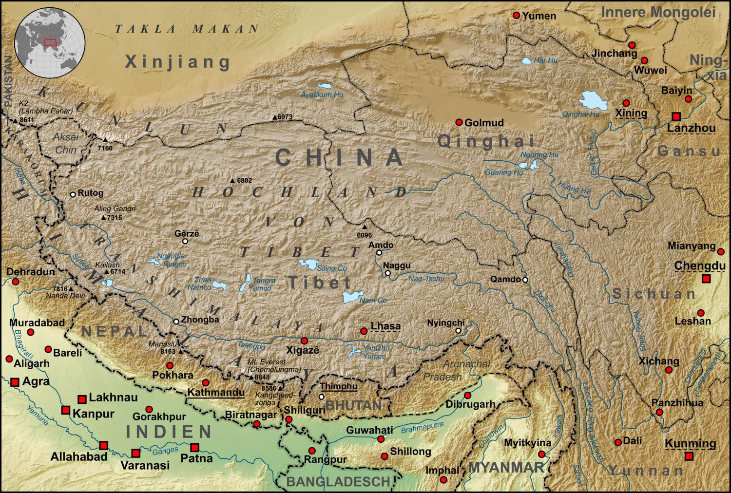
| Kuvaus | Topographische Karte der chinesischen autonomen Provinz Tibet, sowie der umliegenden chinesischen Provinzen und der angrenzenden Länder |
| Päiväys | |
| Lähde |
own work, used:
|
| Tekijä | Lencer |
| Muut versiot | Tämän tiedoston johdannaisteoksia: ZabuyeLake1.png |
Tämä tiedosto on lisensoitu Creative Commons Nimeä-JaaSamoin 3.0 Ei sovitettu -lisenssillä.
- Voit:
- jakaa – kopioida, levittää ja esittää teosta
- remiksata – valmistaa muutettuja teoksia
- Seuraavilla ehdoilla:
- nimeäminen – Sinun on mainittava lähde asianmukaisesti, tarjottava linkki lisenssiin sekä merkittävä, mikäli olet tehnyt muutoksia. Voit tehdä yllä olevan millä tahansa kohtuullisella tavalla, mutta et siten, että annat ymmärtää lisenssinantajan suosittelevan sinua tai teoksen käyttöäsi.
- jaa samoin – Jos muutat tai perustat tähän työhön, voit jakaa tuloksena syntyvää työtä vain tällä tai tämän kaltaisella lisenssillä.

|
Saksankielisen Wikipedian projekti Kartenwerkstatt on parantanut tätä karttaa. Myös sinä voit ehdottaa jotakin karttaa parannettavaksi.
|
Tiedoston historia
Päiväystä napsauttamalla näet, millainen tiedosto oli kyseisellä hetkellä.
| Päiväys | Pienoiskuva | Koko | Käyttäjä | Kommentti | |
|---|---|---|---|---|---|
| nykyinen | 28. lokakuuta 2015 kello 09.30 | | 1 500 × 1 012 (3,08 MiB) | Lencer | Ulugh Muztagh now 6973 m |
| 28. lokakuuta 2015 kello 09.30 |  | 3 240 × 2 185 (12,63 MiB) | Lencer | Ulugh Muztagh now 6973 m | |
| 1. maaliskuuta 2009 kello 16.11 |  | 1 500 × 1 012 (3,11 MiB) | Lencer | Einige Korrekturen und Ergänzungen | |
| 13. joulukuuta 2008 kello 00.22 |  | 1 500 × 1 012 (3,11 MiB) | Lencer | {{Information |Description= |Source= |Date= |Author= |Permission= |other_versions= }} | |
| 12. joulukuuta 2008 kello 11.18 |  | 1 500 × 1 012 (3,11 MiB) | Lencer | {{Information |Description= |Source= |Date= |Author= |Permission= |other_versions= }} | |
| 11. joulukuuta 2008 kello 15.57 |  | 1 500 × 1 012 (3,11 MiB) | Lencer | {{Information |Description= |Source= |Date= |Author= |Permission= |other_versions= }} | |
| 22. marraskuuta 2008 kello 15.13 |  | 1 500 × 1 012 (3,1 MiB) | Lencer | {{Information |Description= |Source= |Date= |Author= |Permission= |other_versions= }} | |
| 16. marraskuuta 2008 kello 17.46 |  | 1 500 × 1 012 (3,09 MiB) | Lencer | {{Information| |Description=Topograhische Karte der chinesischen autonomen Provinz Tibet, sowie der umliegenden chinesischen Provinzen und der angrenzenden Länder |Source=own work, used: * Generic Mapping Tools and SRTM30-fi |
Tiedoston käyttö
Seuraava sivu käyttää tätä tiedostoa:
Tiedoston järjestelmänlaajuinen käyttö
Seuraavat muut wikit käyttävät tätä tiedostoa:
- Käyttö kohteessa af.wikipedia.org
- Käyttö kohteessa ar.wikipedia.org
- Käyttö kohteessa ast.wikipedia.org
- Käyttö kohteessa az.wikipedia.org
- Käyttö kohteessa bo.wikipedia.org
- Käyttö kohteessa ca.wikipedia.org
- Käyttö kohteessa ceb.wikipedia.org
- Käyttö kohteessa ckb.wikipedia.org
- Käyttö kohteessa de.wikipedia.org
- Kunlun
- Transhimalaya
- Autonomes Gebiet Tibet
- Diskussion:Karakorum (Gebirge)
- Hochland von Tibet
- Benutzer:Lencer
- Benutzer:Lencer/Galerie
- Wikipedia:Kartenwerkstatt/Archiv/2008-12
- Diskussion:Transhimalaya
- Wikipedia Diskussion:Hauptseite/Artikel des Tages/Archiv/Vorschläge/2013/Q1
- Wikipedia:Hauptseite/Archiv/14. Februar 2013
- Tibet (1912–1951)
- Pinjarra-Orogen
- Tektonische Entwicklung des indischen Subkontinents
- Geologie des Transhimalayas
- Geologie der Indus-Yarlung suture zone
- Käyttö kohteessa el.wikipedia.org
- Käyttö kohteessa en.wikipedia.org
- Käyttö kohteessa eo.wikipedia.org
- Käyttö kohteessa es.wikipedia.org
- Käyttö kohteessa eu.wikipedia.org
- Käyttö kohteessa frr.wikipedia.org
- Käyttö kohteessa fr.wikipedia.org
- Käyttö kohteessa ga.wikipedia.org
- Käyttö kohteessa gl.wikipedia.org
- Käyttö kohteessa he.wikivoyage.org
- Käyttö kohteessa hi.wikipedia.org
- Käyttö kohteessa hu.wikipedia.org
- Käyttö kohteessa hy.wikipedia.org
- Käyttö kohteessa it.wikipedia.org
- Käyttö kohteessa ja.wikipedia.org
- Käyttö kohteessa ku.wikipedia.org
- Käyttö kohteessa lld.wikipedia.org
- Käyttö kohteessa lt.wikipedia.org
Näytä lisää tämän tiedoston järjestelmänlaajuista käyttöä.