Tiedosto:Remains of Nero's Isthmus Canal in 1881.jpg
Siirry navigaatioon
Siirry hakuun

Tämän esikatselun koko: 800 × 507 kuvapistettä. Muut resoluutiot: 320 × 203 kuvapistettä | 640 × 405 kuvapistettä | 1 200 × 760 kuvapistettä.
Alkuperäinen tiedosto (1 200 × 760 kuvapistettä, 225 KiB, MIME-tyyppi: image/jpeg)
| Tämä tiedosto on tiedostotietokanta Wikimedia Commonsista. Tiedot kuvaussivulta näkyvät alla. |  |
Tiedoston kuvaussivu Commonsissa |
Yhteenveto
| Kuvaus |
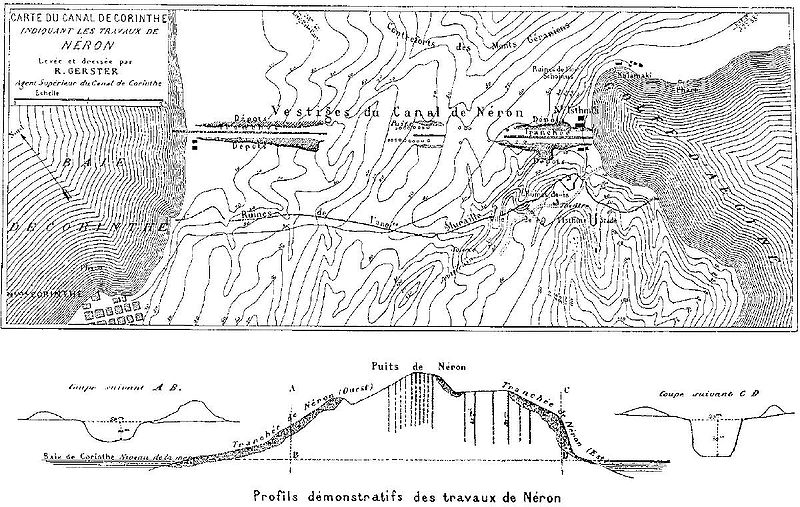
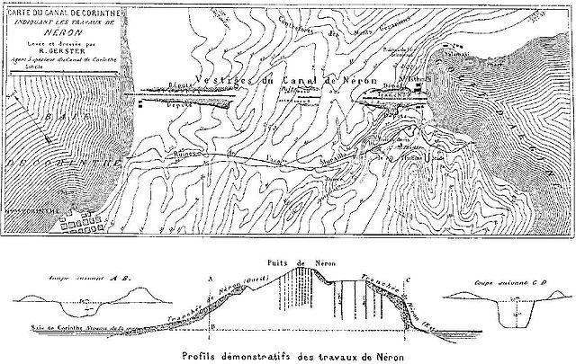
Deutsch: Überreste von Neros Projekt, einen Kanal durch den Isthmus von Korinth zu stechen (67 n. Chr.). Die dunkel schraffierten Bereiche markieren die antiken Aushubarbeiten. Die senkrechten Schächte im Bild unten dienten den Römern zur Begutachtung des Steinmaterials in der Tiefe. Die Karte wurde vom Chefingenieur des modernen Kanalprojekts Bela Gerster 1881 bei der Erkundung der Landenge angefertigt.
English: Remains of Nero's aborted project to cut through the Isthmus of Corinth (67 AD). The Roman digging is indicated by the dark shaded areas. The vertical shafts in the cross section below were excavated by the Romans to probe the stone material. The map was drawn by chief engineer Bela Gerster in 1881 during his survey for the modern canal. |
| Päiväys | |
| Lähde | Werner, Walter: "The largest ship trackway in ancient times: the Diolkos of the Isthmus of Corinth, Greece, and early attempts to build a canal", The International Journal of Nautical Archaeology, Vol. 26, No. 2 (1997), pp. 98–119 (114, Fig. 25) |
| Tekijä | Bela Gerster (1850–1923) |
| Muut versiot |
.jpg)

|
Tämä tyyppiä old map oleva kuva pitäisi luoda uudelleen SVG-tiedostoksi vektorigrafiikan avulla. Tällä tiedostotyypillä on monia vahvuuksia, sivulta Commons:Media for cleanup löytyy lisätietoja. Jos tästä kuvasta on jo olemassa SVG-versio, ole ystävällinen ja tallenna se tänne. SVG-tiedoston tallentamisen jälkeen vaihda tämä malline mallineeseen {{vector version available|uusi kuvan nimi.svg}}.
|


Lisenssi
|
Tämä teos on public domainissa lähes maailmanlaajuisesti, koska tekijän kuolemasta on kulunut yli 100 vuotta. Tämä teos on ilman tekijänoikeuden suojaa Yhdysvalloissa, sillä se on julkaistu (tai rekisteröity Yhdysvaltojen tekijänoikeusvirastossa) ennen vuotta 1929. | |
| Tämä teos on vapaa tunnetuista tekijänoikeuslain mukaisista rajoituksista, mukaanlukien lähioikeuksista. | |
Tiedoston historia
Päiväystä napsauttamalla näet, millainen tiedosto oli kyseisellä hetkellä.
| Päiväys | Pienoiskuva | Koko | Käyttäjä | Kommentti | |
|---|---|---|---|---|---|
| nykyinen | 15. tammikuuta 2008 kello 19.46 | | 1 200 × 760 (225 KiB) | Gun Powder Ma | == Summary == {{Information |Description= {{de| Überreste von Neros Projekt, einen Kanal durch den Isthmus von Korinth zu stechen. Die Karte wurde vom Chefingenieur des modernen Kanalprojekts Bela Gerster 1881 bei der Erkundung der Landenge gezeichnet. D |
| 15. tammikuuta 2008 kello 19.38 |  | 751 × 476 (102 KiB) | Gun Powder Ma | {{Information |Description= {{de| Überreste von Neros Projekt, einen Kanal durch den Isthmus von Korinth zu stechen. Die Karte wurde vom Chefingenieur des modernen Kanalprojekts Bela Gerster 1881 bei der Erkundung der Landenge gezeichnet. Die senkrechten |
Tiedoston käyttö
Seuraavat 2 sivua käyttävät tätä tiedostoa:
Tiedoston järjestelmänlaajuinen käyttö
Seuraavat muut wikit käyttävät tätä tiedostoa:
- Käyttö kohteessa als.wikipedia.org
- Käyttö kohteessa az.wikipedia.org
- Käyttö kohteessa be.wikipedia.org
- Käyttö kohteessa bg.wikipedia.org
- Käyttö kohteessa da.wikipedia.org
- Käyttö kohteessa de.wikipedia.org
- Käyttö kohteessa en.wikipedia.org
- Käyttö kohteessa es.wikipedia.org
- Käyttö kohteessa et.wikipedia.org
- Käyttö kohteessa fr.wikipedia.org
- Käyttö kohteessa hyw.wikipedia.org
- Käyttö kohteessa it.wikipedia.org
- Käyttö kohteessa nn.wikipedia.org
- Käyttö kohteessa no.wikipedia.org
- Käyttö kohteessa ro.wikipedia.org
- Käyttö kohteessa ru.wikipedia.org
- Käyttö kohteessa sk.wikipedia.org
- Käyttö kohteessa sl.wikipedia.org
- Käyttö kohteessa sq.wikipedia.org
- Käyttö kohteessa sv.wikipedia.org
- Käyttö kohteessa tr.wikipedia.org
- Käyttö kohteessa uk.wikipedia.org
- Käyttö kohteessa vi.wikipedia.org