Tiedosto:Reichskommissariat Ostland Administrative.png
Siirry navigaatioon
Siirry hakuun

Tämän esikatselun koko: 415 × 599 kuvapistettä. Muut resoluutiot: 166 × 240 kuvapistettä | 333 × 480 kuvapistettä | 532 × 768 kuvapistettä | 710 × 1 024 kuvapistettä | 1 420 × 2 048 kuvapistettä | 2 856 × 4 120 kuvapistettä.
Alkuperäinen tiedosto (2 856 × 4 120 kuvapistettä, 1,89 MiB, MIME-tyyppi: image/png)
| Tämä tiedosto on tiedostotietokanta Wikimedia Commonsista. Tiedot kuvaussivulta näkyvät alla. |  |
Tiedoston kuvaussivu Commonsissa |
Yhteenveto
| Kuvaus |
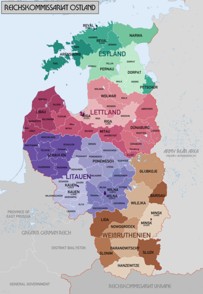
English: Administrative Map of Reichskommissariat Ostland |
| Päiväys | |
| Lähde | Oma teos |
| Tekijä | XrysD |
| Muut versiot |
Tämän tiedoston johdannaisteoksia: Gen Okrug Belarus Administrative.png Tämän tiedoston johdannaisteoksia: Generalbezirk Lettland.png |
Lisenssi
Minä, tämän teoksen tekijänoikeuksien haltija, julkaisen täten tämän teoksen seuraavilla lisensseillä:

|
Voit kopioida, levittää ja/tai muuttaa tätä asiakirjaa GNU Free Documentation License -lisenssin version 1.2 tai minkä tahansa Free Software Foundationin julkaiseman myöhemmän version ehtojen alaisena; ei koske muuttumattomia kohtia, etukannen tekstejä eikä takakannen tekstejä. Kopio tästä lisenssistä on saatavilla osiossa GNU Free Documentation License. |
| Tämä tiedosto on lisensoitu Creative Commons Nimeä-JaaSamoin 3.0 Ei sovitettu -lisenssillä. | ||
| ||
| Lisensointimerkintä lisätiin tähän tiedostoon osana GFDL-lisensointipäivitystä. |
| Käyttäjänoikeus: Tämä taiteellinen teos on vapaa; voit levittää ja/tai muokata sitä Free Art License -lisenssin ehdoilla. Lisenssiteksti on saatavilla Copyleft Attitude -sivustolta ja muilta sivustoilta. |
Voit valita haluamasi lisenssin.
Tiedoston historia
Päiväystä napsauttamalla näet, millainen tiedosto oli kyseisellä hetkellä.
| Päiväys | Pienoiskuva | Koko | Käyttäjä | Kommentti | |
|---|---|---|---|---|---|
| nykyinen | 20. helmikuuta 2018 kello 23.46 | | 2 856 × 4 120 (1,89 MiB) | XrysD | Changed map colours to use ColorBrewer Wikipedia recommended palette. |
| 20. helmikuuta 2018 kello 16.33 |  | 2 856 × 4 120 (1,86 MiB) | XrysD | New version reduced legibility - e.g. borders in Riga District now invisible. | |
| 16. helmikuuta 2018 kello 00.18 |  | 2 856 × 4 120 (2,62 MiB) | 1970gemini | fiat lux | |
| 11. toukokuuta 2017 kello 20.47 |  | 2 856 × 4 120 (1,86 MiB) | XrysD | Fixed typo in source graphic and re-rendered output PNG to avoid loss of quality due to editing render rather than source. | |
| 11. toukokuuta 2017 kello 17.58 |  | 2 856 × 4 120 (1,92 MiB) | Намѣсникъ | name of Dünaburg (not Dünaberg) corrected | |
| 22. huhtikuuta 2017 kello 19.25 |  | 2 856 × 4 120 (1,71 MiB) | XrysD | Added missing labels | |
| 22. huhtikuuta 2017 kello 18.54 |  | 2 856 × 4 120 (1,69 MiB) | XrysD | Completely new version. Source map data: [Karte des Deutschen Reiches (Grossblatter) 1:100k, Mapa Administracyjna Rzeczypospolitej Polska 1:300k, Verwaltungskarte_Weissruthenien_u.Ssmolensk_1M_Ausg.1_(B)_X.1942, 1:500k, Strassenkarte der Baltischen Lae... | |
| 1. syyskuuta 2015 kello 19.50 |  | 1 548 × 2 139 (1,04 MiB) | Poeticbent | added missing subdivisions | |
| 20. syyskuuta 2008 kello 01.03 |  | 1 548 × 2 139 (962 KiB) | XrysD | {{Information |Description={{en|1=Administrative Map of Reichskommissariat Ostland}} |Source=Own work by uploader |Author=XrysD |Date=19/09/2008 |Permission= |other_versions= }} <!--{{ImageUpload|full}}--> |
Tiedoston käyttö
Seuraavat 4 sivua käyttävät tätä tiedostoa:
Tiedoston järjestelmänlaajuinen käyttö
Seuraavat muut wikit käyttävät tätä tiedostoa:
- Käyttö kohteessa ar.wikipedia.org
- Käyttö kohteessa az.wikipedia.org
- Käyttö kohteessa be-tarask.wikipedia.org
- Käyttö kohteessa be.wikipedia.org
- Käyttö kohteessa bs.wikipedia.org
- Käyttö kohteessa ca.wikipedia.org
- Käyttö kohteessa cs.wikipedia.org
- Käyttö kohteessa da.wikipedia.org
- Käyttö kohteessa de.wikipedia.org
- Käyttö kohteessa en.wikipedia.org
- Reichskommissariat Ostland
- Demographic history of the Vilnius region
- Reichskommissariat
- German occupation of Lithuania during World War II
- Generalbezirk Litauen
- Wikipedia:WikiProject Military history/News/August 2012/Op-ed
- Generalbezirk Estland
- Generalbezirk Lettland
- Walther Schröder
- Karl Schäfer (SS-Brigadeführer)
- Generalbezirk Weißruthenien
- Talk:Lithuanian Territorial Defense Force/Archive 1
- Käyttö kohteessa es.wikipedia.org
- Käyttö kohteessa et.wikipedia.org
- Käyttö kohteessa fr.wikipedia.org
Näytä lisää tämän tiedoston järjestelmänlaajuista käyttöä.