Tiedosto:Northern Mali conflict.svg
Siirry navigaatioon
Siirry hakuun

Tämän PNG-esikatselun koko koskien SVG-tiedostoa: 629 × 600 kuvapistettä. Muut resoluutiot: 252 × 240 kuvapistettä | 503 × 480 kuvapistettä | 805 × 768 kuvapistettä | 1 074 × 1 024 kuvapistettä | 2 148 × 2 048 kuvapistettä | 1 316 × 1 255 kuvapistettä.
Alkuperäinen tiedosto (SVG-tiedosto; oletustarkkuus 1 316 × 1 255 kuvapistettä; tiedostokoko 796 KiB)
| Tämä tiedosto on tiedostotietokanta Wikimedia Commonsista. Tiedot kuvaussivulta näkyvät alla. |  |
Tiedoston kuvaussivu Commonsissa |
Yhteenveto
| Kuvaus |
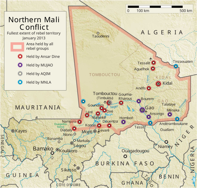
English: Map of the conflict in Northern Mali. (English)
العربية: خريطة الصّراع في شمال مالي. (إنجليزي)
Français : Carte du conflit au nord du Mali. (Anglais)
Latina: Charta rebellionis Tuaregorum in Malia septentrionali. (Anglice)
Українська: Карта конфлікту на півночі Малі. (Англійською) |
| Lähde |
Oma teos This vector image includes elements that have been taken or adapted from this file: This vector image includes elements that have been taken or adapted from this file: |
| Tekijä | Orionist |
| Muut versiot | German/Deutsch/Allemand, French/Français, Macedonian/македонски јазик/Macédonien |
| SVG kehittely |
Notes
- ↑ US Department of State, "Country Reports on Terrorism 2011", Chapter 2 Country Reports: Africa Overview, 31 July 2012
Lisenssi
Minä, tämän teoksen tekijänoikeuksien haltija, julkaisen täten tämän teoksen seuraavalla lisenssillä:
Tämä tiedosto on lisensoitu Creative Commons Nimeä-JaaSamoin 3.0 Ei sovitettu -lisenssillä.
- Voit:
- jakaa – kopioida, levittää ja esittää teosta
- remiksata – valmistaa muutettuja teoksia
- Seuraavilla ehdoilla:
- nimeäminen – Sinun on mainittava lähde asianmukaisesti, tarjottava linkki lisenssiin sekä merkittävä, mikäli olet tehnyt muutoksia. Voit tehdä yllä olevan millä tahansa kohtuullisella tavalla, mutta et siten, että annat ymmärtää lisenssinantajan suosittelevan sinua tai teoksen käyttöäsi.
- jaa samoin – Jos muutat tai perustat tähän työhön, voit jakaa tuloksena syntyvää työtä vain tällä tai tämän kaltaisella lisenssillä.
Tiedoston historia
Päiväystä napsauttamalla näet, millainen tiedosto oli kyseisellä hetkellä.
| Päiväys | Pienoiskuva | Koko | Käyttäjä | Kommentti | |
|---|---|---|---|---|---|
| nykyinen | 8. huhtikuuta 2014 kello 09.59 | | 1 316 × 1 255 (796 KiB) | Ansh666 | Reverted to version as of 16:51, 8 March 2013 - restoring the correct version, as the map is supposed to be historical, not current |
| 5. joulukuuta 2013 kello 23.15 |  | 1 316 × 1 255 (699 KiB) | Hanibal911 | more accurately reflects the situation | |
| 8. maaliskuuta 2013 kello 19.51 |  | 1 316 × 1 255 (796 KiB) | Agricolae | Hombori dot restored | |
| 5. maaliskuuta 2013 kello 17.29 |  | 1 316 × 1 255 (794 KiB) | TUFKAAP | Since this is an English map, Al-Qaeda in the Islamic Maghreb should be abbreviated as AQIM. | |
| 11. helmikuuta 2013 kello 06.33 |  | 1 316 × 1 255 (794 KiB) | Agricolae | shift text distorted on upload | |
| 11. helmikuuta 2013 kello 06.27 |  | 1 316 × 1 255 (794 KiB) | Agricolae | change to show greatest extent - see WP Talk:Northern Mali conflict (2012–present) | |
| 8. helmikuuta 2013 kello 09.36 |  | 1 316 × 1 255 (699 KiB) | Rama | Aguelhok contested or taken ( http://www.lemonde.fr/afrique/article/2013/02/08/mali-les-forces-francaise-et-tchadiennes-a-aguelhok_1828906_3212.html ) | |
| 2. helmikuuta 2013 kello 13.29 |  | 1 316 × 1 255 (698 KiB) | U5K0 | Bourem to green as per talk page | |
| 30. tammikuuta 2013 kello 11.41 |  | 1 316 × 1 255 (679 KiB) | Orionist | Updated map: Menaka, Anderamboukane, Ansongo, Dire, Kidal and other MNLA positions. Removed rebel area boundaries as the situation has become complicated. | |
| 29. tammikuuta 2013 kello 20.23 |  | 1 316 × 1 255 (894 KiB) | Jaybear | Insertion of a map-scale in the upper right corner (added directly before the token "/svg" at end of svg-code); |
Tiedoston käyttö
Seuraavat 2 sivua käyttävät tätä tiedostoa:
Tiedoston järjestelmänlaajuinen käyttö
Seuraavat muut wikit käyttävät tätä tiedostoa:
- Käyttö kohteessa af.wikipedia.org
- Käyttö kohteessa ar.wikipedia.org
- Käyttö kohteessa azb.wikipedia.org
- Käyttö kohteessa az.wikipedia.org
- Käyttö kohteessa bg.wikipedia.org
- Käyttö kohteessa bn.wikipedia.org
- Käyttö kohteessa ca.wikipedia.org
- Käyttö kohteessa cs.wikipedia.org
- Käyttö kohteessa cy.wikipedia.org
- Käyttö kohteessa da.wikipedia.org
- Käyttö kohteessa de.wikipedia.org
- Käyttö kohteessa el.wikipedia.org
- Käyttö kohteessa en.wikipedia.org
- Mali
- Portal:Mali
- Insurgency in the Maghreb (2002–present)
- War on terror
- User:Orionist/Gallery
- National Movement for the Liberation of Azawad
- Wikipedia talk:WikiProject Maps/Archive 2012
- Wikipedia:In the news/Candidates/April 2012
- Wikipedia:Graphics Lab/Map workshop/Archive/Apr 2012
- Wikipedia:Wikipedia Signpost/2012-04-30/WikiProject report
- Wikipedia:Wikipedia Signpost/Single/2012-04-30
- Mali War
- Wikipedia:WikiProject Maps/Conventions/Pushpin maps
- Operation Serval
- Chadian intervention in northern Mali
- Islamist insurgency in the Sahel
- User:AlbanianEditor1990/sandbox
- Käyttö kohteessa en.wikinews.org
- Käyttö kohteessa eo.wikipedia.org
- Käyttö kohteessa es.wikipedia.org
- Käyttö kohteessa et.wikipedia.org
- Käyttö kohteessa eu.wikipedia.org
- Käyttö kohteessa fr.wikiquote.org
- Käyttö kohteessa he.wikipedia.org
Näytä lisää tämän tiedoston järjestelmänlaajuista käyttöä.