Tiedosto:Decolonization - World In 1945 en.svg

Alkuperäinen tiedosto (SVG-tiedosto; oletustarkkuus 1 421 × 816 kuvapistettä; tiedostokoko 802 KiB)
| Tämä tiedosto on tiedostotietokanta Wikimedia Commonsista. Tiedot kuvaussivulta näkyvät alla. |  |
Tiedoston kuvaussivu Commonsissa |
Yhteenveto
| Kuvaus |
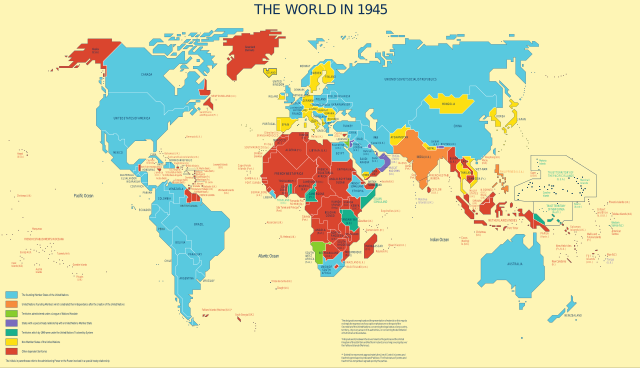
English: Map was used to show the progress of the UN's decolonization efforts.
Derivative work based on UN Map No. 4135 Rev. 3, updated in May 2010 by UN Department of Field Support, Cartographic Section Taken from the UN's decolonization website. Only modification was a conversion to SVG and per UN license, removal of reference information from the map. In fulfillment of a Wikipedia Graphics Lab: Map Workshop request by User:Gryffindor, referencing a photo taken by User:Deror_avi at the UN building.English: The founding Member States of the UN English: UN founding Members which celebrated their independence after the creation of the UN English: Territories administered under a League of Nations Mandate English: States with a special treaty relationship with a UN Member State English: Territories which by 1949 were under the UN Trusteeship System English: Non-Member States of the UN English: Other dependent territories |
|||
| Päiväys | Tuntematon päiväys, last update in May 2010 | |||
| Lähde | The United Nations and Decolonization | |||
| Tekijä | United Nations Department of Field Support, Cartographic Section | |||
| Käyttöoikeus (Tämän tiedoston uudelleenkäyttö) |
|

Tiedoston historia
Päiväystä napsauttamalla näet, millainen tiedosto oli kyseisellä hetkellä.
| Päiväys | Pienoiskuva | Koko | Käyttäjä | Kommentti | |
|---|---|---|---|---|---|
| nykyinen | 9. heinäkuuta 2022 kello 04.31 | | 1 421 × 816 (802 KiB) | Kwamikagami | Reverted to version as of 22:10, 21 May 2012 (UTC) |
| 9. heinäkuuta 2022 kello 04.29 |  | 1 421 × 816 (802 KiB) | Kwamikagami | official UN blue, #009edb | |
| 22. toukokuuta 2012 kello 01.10 |  | 1 421 × 816 (802 KiB) | 25or6to4 | updated to approved font, should fix location issues | |
| 12. toukokuuta 2011 kello 23.24 |  | 1 421 × 816 (533 KiB) | Ras67 | frame removed | |
| 8. syyskuuta 2010 kello 01.15 |  | 1 438 × 832 (497 KiB) | Gringer | Arial font, some unnecessary styles removed | |
| 7. syyskuuta 2010 kello 07.51 |  | 1 438 × 832 (4,38 MiB) | Lesqual | Uploaded with fonts converted to paths so that WP can render text properly until it gets a better RSVG implementation - if you need to modify, use previous revision. | |
| 7. syyskuuta 2010 kello 07.32 |  | 1 438 × 832 (616 KiB) | Lesqual | {{Information |Description={{en|1=Map was used to show the progress of the UN's decolonization efforts. Derivative work based on UN Map No. 4135 Rev. 3, updated in May 2010 by UN Department of Field Support, Cartographic Section Taken from the UN's deco |
Tiedoston käyttö
Seuraavat 2 sivua käyttävät tätä tiedostoa:
Tiedoston järjestelmänlaajuinen käyttö
Seuraavat muut wikit käyttävät tätä tiedostoa:
- Käyttö kohteessa bg.wikipedia.org
- Käyttö kohteessa bn.wikipedia.org
- Käyttö kohteessa ca.wikipedia.org
- Käyttö kohteessa cs.wikipedia.org
- Käyttö kohteessa cy.wikipedia.org
- Käyttö kohteessa de.wikipedia.org
- Käyttö kohteessa en.wikipedia.org
- Käyttö kohteessa es.wikipedia.org
- Käyttö kohteessa fa.wikipedia.org
- Käyttö kohteessa fr.wikipedia.org
- Käyttö kohteessa id.wikipedia.org
- Käyttö kohteessa ko.wikipedia.org
- Käyttö kohteessa ms.wikipedia.org
- Käyttö kohteessa ne.wikipedia.org
- Käyttö kohteessa nl.wikipedia.org
- Käyttö kohteessa no.wikipedia.org
- Käyttö kohteessa pa.wikipedia.org
- Käyttö kohteessa pt.wikipedia.org
- Käyttö kohteessa sh.wikipedia.org
- Käyttö kohteessa sk.wikipedia.org
- Käyttö kohteessa so.wikipedia.org
- Käyttö kohteessa sv.wikipedia.org
- Käyttö kohteessa ta.wikipedia.org
- Käyttö kohteessa th.wikipedia.org
- Käyttö kohteessa uz.wikipedia.org
- Käyttö kohteessa vi.wikipedia.org
- Käyttö kohteessa zh.wikipedia.org