Tiedosto:Carleton Coon races after Pleistocene.PNG
Alkuperäinen tiedosto (1 357 × 628 kuvapistettä, 36 KiB, MIME-tyyppi: image/png)
| Tämä tiedosto on tiedostotietokanta Wikimedia Commonsista. Tiedot kuvaussivulta näkyvät alla. |  |
Tiedoston kuvaussivu Commonsissa |
Yhteenveto
| Kuvaus |
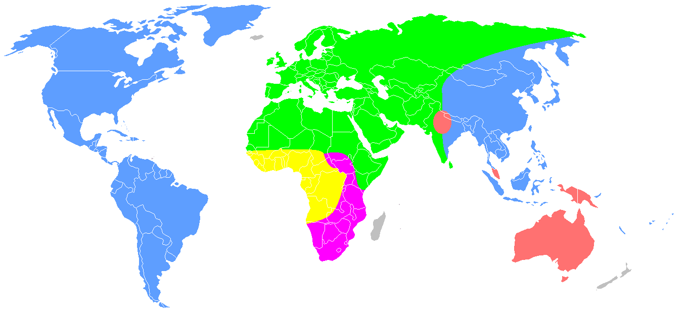
English: Redrawing of a map from Carleton S. Coon, The Origin of Races (1962), p. 659.
Distribution of Coon's "five geographical races of man" after the end of the Pleistocene. This is the second of the two maps numbered "Map 13", labelled "Early Post-Pleistocene". Original caption: "The second map shows what happened at the end of the Pleistocene, when the Mongoloids and Caucasoids expanded and burst out of their territories. The Mongoloids entered and inhabited America, and extended their domain southward into Southeast Asia and Indonesia, while the Australoids crossed Wallace's Line and occupied Australia and New Guinea. The Caucasoids thrust northward. More significantly, they drove the Capoids out of North Africa and occupied the White Highlands of Kenya and Tanganyika. The Congoids were reduced to a small part of their earlier domain, including the Congo forests and the lands to the north, where they later evolved rapidly and spread, as Negroes, over much of Africa." Some of these hypotheses are no longer tenable, it is now known that the Proto-Australoid peopling of Australia is much earlier, and that the Capoids developed in South, not North Africa.
|
| Päiväys | 1. lokakuuta 2007 (alkuperäinen tallennuspäivä) |
| Lähde | Siirretty projektista en.wikipedia Commonsiin. free-use map of the world from Wikipedia Commons. "The living Races of Man"[1][2] |
| Tekijä | Dark Tea projektissa Wikipedia kielellä englanti |
| Muut versiot |
 |

|
Tämä tyyppiä biogeographical map oleva kuva pitäisi luoda uudelleen SVG-tiedostoksi vektorigrafiikan avulla. Tällä tiedostotyypillä on monia vahvuuksia, sivulta Commons:Media for cleanup löytyy lisätietoja. Jos tästä kuvasta on jo olemassa SVG-versio, ole ystävällinen ja tallenna se tänne. SVG-tiedoston tallentamisen jälkeen vaihda tämä malline mallineeseen {{vector version available|uusi kuvan nimi.svg}}.
|
Legend
| Australoids | ||
| Mongoloids | ||
| Caucasoids | ||
| Capoids | ||
| Congoids |
Lisenssi

|
Voit kopioida, levittää ja/tai muuttaa tätä asiakirjaa GNU Free Documentation License -lisenssin version 1.2 tai minkä tahansa Free Software Foundationin julkaiseman myöhemmän version ehtojen alaisena; ei koske muuttumattomia kohtia, etukannen tekstejä eikä takakannen tekstejä. Kopio tästä lisenssistä on saatavilla osiossa GNU Free Documentation License. |
- Voit:
- jakaa – kopioida, levittää ja esittää teosta
- remiksata – valmistaa muutettuja teoksia
- Seuraavilla ehdoilla:
- nimeäminen – Sinun on mainittava lähde asianmukaisesti, tarjottava linkki lisenssiin sekä merkittävä, mikäli olet tehnyt muutoksia. Voit tehdä yllä olevan millä tahansa kohtuullisella tavalla, mutta et siten, että annat ymmärtää lisenssinantajan suosittelevan sinua tai teoksen käyttöäsi.
- jaa samoin – Jos muutat tai perustat tähän työhön, voit jakaa tuloksena syntyvää työtä vain tällä tai tämän kaltaisella lisenssillä.
Alkuperäinen tallennusloki
- 2007-10-01 10:13 Dark Tea 1357×628×8 (48426 bytes) This is a recreation of Carleton Coon's racial map [http://www.snpa.nordish.net/index2.htm source]. It is made from a free-use image of the world found on Wikipedia. It is made to replace the previous I made which was innacurate.--~~~~
- ↑ https://www.jstor.org/stable/2740426?seq=1#page_scan_tab_contents
- ↑ https://archive.org/stream/B-001-001-289#page/n567/mode/2up
Tiedoston historia
Päiväystä napsauttamalla näet, millainen tiedosto oli kyseisellä hetkellä.
| Päiväys | Pienoiskuva | Koko | Käyttäjä | Kommentti | |
|---|---|---|---|---|---|
| nykyinen | 19. lokakuuta 2020 kello 13.20 | | 1 357 × 628 (36 KiB) | Bidgee | Reverted to version as of 09:48, 19 October 2020 (UTC) Enough! COM:OVERWRITE is there for a reason and is on the very page used to upload and revert. Please stop. |
| 19. lokakuuta 2020 kello 13.10 |  | 1 357 × 628 (35 KiB) | Intonraiha | ? I have already included a new reference. Read it. | |
| 19. lokakuuta 2020 kello 12.48 |  | 1 357 × 628 (36 KiB) | Rsk6400 | Reverted to version as of 19:22, 25 September 2020 (UTC) - See Discussion, section "South Asia". If you have a better source, name it on the discussion page. | |
| 19. lokakuuta 2020 kello 12.01 |  | 1 357 × 628 (35 KiB) | Intonraiha | It is not sourced. The source does support this map. As others have discussed in the talk page. The references clearly mention the border as with in this version. It is not about Coons first version. | |
| 18. lokakuuta 2020 kello 22.55 |  | 1 357 × 628 (36 KiB) | Rsk6400 | Reverted to version as of 19:22, 25 September 2020 (UTC) - This version corresponds to Coon's original version | |
| 9. lokakuuta 2020 kello 22.58 |  | 1 357 × 628 (35 KiB) | BoxofPandoraisopened | Restoring cited version. If we use such a map, we should use the version which Coon ultimately proposed and not a prototype version. | |
| 25. syyskuuta 2020 kello 22.22 |  | 1 357 × 628 (36 KiB) | Fæ | Reverted to version as of 09:48, 25 September 2020 (UTC) Restore, per File:The Origin of Races, map 13 (IA B-001-001-289).jpg. Please avoid adding user interpretations when the published 1962 map can be directly referenced. | |
| 25. syyskuuta 2020 kello 22.04 |  | 1 357 × 628 (34 KiB) | Fylindfotberserk | I'm restoring the south Asian part as per "Living Races Of Man" and "The Origin of Races", plains of Assam (Brahmaputra) and Bengal are settled by Caucasoids. page 485 of "The Origin of Races" writes "Caucasoid and Mongoloid had a common border at the "Edges of the Assam and Bengal plains." | |
| 25. syyskuuta 2020 kello 12.48 |  | 1 357 × 628 (36 KiB) | Fæ | Reverted to version as of 14:58, 10 March 2018 (UTC) removing the changes of multiple sockpuppet accounts | |
| 15. elokuuta 2019 kello 04.06 |  | 1 357 × 628 (35 KiB) | LenguaMapa | Reverted to version as of 19:07, 1 July 2019 (UTC) revert back (this is after pleistocene...) |
.jpg&action=edit&redlink=1)
Tiedoston käyttö
Tätä tiedostoa ei käytetä millään sivulla.
Tiedoston järjestelmänlaajuinen käyttö
Seuraavat muut wikit käyttävät tätä tiedostoa:
- Käyttö kohteessa bg.wikipedia.org
- Käyttö kohteessa en.wikipedia.org
- Käyttö kohteessa es.wikipedia.org
- Käyttö kohteessa fr.wikipedia.org
- Käyttö kohteessa hr.wikipedia.org
- Käyttö kohteessa it.wikipedia.org
- Käyttö kohteessa ml.wikipedia.org
- Käyttö kohteessa no.wikipedia.org
- Käyttö kohteessa tl.wikipedia.org
- Käyttö kohteessa uk.wikipedia.org