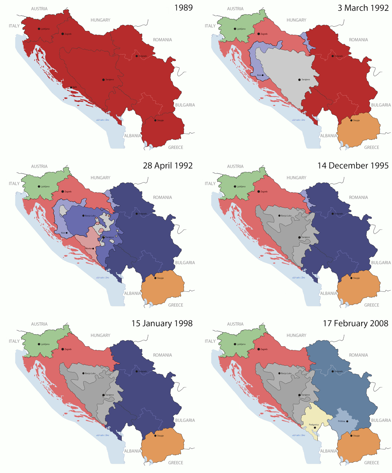
Tiedosto:Breakup of Yugoslavia.gif

Wikipediasta
Siirry navigaatioon Siirry hakuun

Alkuperäinen tiedosto(1 545 × 1 242 kuvapistettä, 187 KiB, MIME-tyyppi: image/gif, toistuva, 14 kehystä, 44 s)

This image could be re-created using vector graphics as an SVG file. This has several advantages; see Commons:Media for cleanup for more information. If an SVG form of this image is available, please upload it and afterwards replace this template with {{vector version available|new image name}}. It is recommended to name the SVG file "Breakup of Yugoslavia.svg" - then the template Vector version available (or Vva) does not need the new image name parameter.

Yhteenveto

Key:

Yugoslavia (1943–1992) SFR Yugoslavia
Croatia (1991–present) Croatia
Herzeg-Bosnia (1992–1994)
UNTAES (1996–1998)
Federal Republic of Yugoslavia / Serbia and Montenegro (1992–2006) Serbia and Montenegro
Republika Srpska (1992–present) Republika Srpska
Serbian Krajina (1991–1995/96)
Republic of Bosnia and Herzegovina (1992–1995)
Bosnia and Herzegovina (1998–present) Bosnia and Herzegovina
Western Bosnia (1993–1995)
Serbia (2006–present) Serbia
Kosovo (under UNMIK control 1999–present; declaration of independence 2008) Kosovo
Montenegro (2006–present) Montenegro
Macedonia (1991–present) Macedonia
Slovenia (1991–present) Slovenia


Kuvaus

This is an animated GIF that shows the stages of the breakup of the SFR Yugoslavia in the 90's and 2000's. The map based off Morwen's map of the divisions of the SFRY, Which is licensed by the GFDL. The source for the dates of independence is the CIA World Factbook. These maps do not now show the Inter-Entity Boundary Line (IEBL) and/or the entities that are separated by it. The IEBL has been drawn based on this CIA map; the Brčko District has been drawn based on Image:BH municipality location.gif, by user:Ante Perkovic. I might add them in the future.

Since the original map was GFDL, this image is as well.

A map depicting Kosovo's final status is ready once it takes effect.


Changelog for versions 2/3:

Here are some changes in this new build of the map:

  • The Kosovo boundary has been given a shade of red instead of the previous UN blue since they are a province of Serbia under UNIMIK control.
  • Montenegro's color has been changed to a golden shade close to what's on the flag.
  • The IEBL and the Brčko District has been redrawn because I deleted the original map; the color for the Republika Srpska is lighter.
  • The dates are at the top left hand corner of the map instead of the bottom.
  • I have taken a new approach as to the boundaries. Each part of Yugoslavia now shows the boundary on the maps starting the year they broke away. I feel this change helps readers understand the breakup better.
  • The SFRY and the FRY are in different shades since the FRY was never accepted as the successor to the former by the UN.
  • The colors for the entities of BiH have been removed as to not confuse people into thinking that they are independent states. What remains is the IEBL with both entities in green.
  • The Kosovo boundary is finally in hash marks!
  • The Brčko District has been removed. The sale is too small to show accurately.

Changelog for version 4:

  • The map is larger!
  • The image has been rebuilt to include the eastern part of FYR Macedonia.
  • The image has been updated to take in Kosovo's new status.
  • The IEBL is now a darker line.
  • Montenegro, Kosovo, and FRY/SCG/Serbia have new colors!

Changelog for version 5:

  • Rebuilt
  • Larger map: size of base image
  • Accurate Inter-Entity Boundary Line
Päiväys 24 July 2006 (orginal upload date)
Lähde Made by Hoshie; see above for more details on sources.
Tekijä Hoshie
Muut versiot

Lisenssi

GNU head Voit kopioida, levittää ja/tai muuttaa tätä asiakirjaa GNU Free Documentation License -lisenssin version 1.2 tai minkä tahansa Free Software Foundationin julkaiseman myöhemmän version ehtojen alaisena; ei koske muuttumattomia kohtia, etukannen tekstejä eikä takakannen tekstejä. Kopio tästä lisenssistä on saatavilla osiossa GNU Free Documentation License.
w:fi:Creative Commons
nimeäminen jaa samoin
Tämä tiedosto on lisensoitu Creative Commons Nimeä-JaaSamoin 3.0 Ei sovitettu -lisenssillä.
Voit:
  • jakaa – kopioida, levittää ja esittää teosta
  • remiksata – valmistaa muutettuja teoksia
Seuraavilla ehdoilla:
  • nimeäminen – Sinun on mainittava lähde asianmukaisesti, tarjottava linkki lisenssiin sekä merkittävä, mikäli olet tehnyt muutoksia. Voit tehdä yllä olevan millä tahansa kohtuullisella tavalla, mutta et siten, että annat ymmärtää lisenssinantajan suosittelevan sinua tai teoksen käyttöäsi.
  • jaa samoin – Jos muutat tai perustat tähän työhön, voit jakaa tuloksena syntyvää työtä vain tällä tai tämän kaltaisella lisenssillä.
Lisensointimerkintä lisätiin tähän tiedostoon osana GFDL-lisensointipäivitystä.

Kuvatekstit

Lisää yhden rivin pituinen kuvaus tästä tiedostosta

Kohteet, joita tässä tiedostossa esitetään

esittää

image/gif

05ca2aefea8406b809968643552d5095c847a42f

191 625 tavu

44 sekunti

1 242 pikseli

1 545 pikseli

Tiedoston historia

Päiväystä napsauttamalla näet, millainen tiedosto oli kyseisellä hetkellä.

(uusimmat | vanhimmat) Näytä [10 | 20 | 50 | 100 | 250 | 500] kerralla. ← 10 uudempaa |
PäiväysPienoiskuvaKokoKäyttäjäKommentti
nykyinen17. heinäkuuta 2016 kello 10.40Pienoiskuva 17. heinäkuuta 2016 kello 10.40 tallennetusta versiosta1 545 × 1 242 (187 KiB)מפתח-רשימהReverted to version as of 17:22, 21 August 2015 (UTC)
21. elokuuta 2015 kello 20.22Pienoiskuva 21. elokuuta 2015 kello 20.22 tallennetusta versiosta1 463 × 1 158 (1,81 MiB)BraganzaReverted to version as of 03:57, 19 January 2010
21. elokuuta 2015 kello 20.22Pienoiskuva 21. elokuuta 2015 kello 20.22 tallennetusta versiosta1 545 × 1 242 (187 KiB)BraganzaReverted to version as of 01:02, 19 December 2011
21. elokuuta 2015 kello 20.15Pienoiskuva 21. elokuuta 2015 kello 20.15 tallennetusta versiosta120 × 95 (3 KiB)Braganza03:57, 19. Jan. 2010
19. joulukuuta 2011 kello 04.02Pienoiskuva 19. joulukuuta 2011 kello 04.02 tallennetusta versiosta1 545 × 1 242 (187 KiB)DIREKTORAdded details
27. heinäkuuta 2011 kello 21.09Pienoiskuva 27. heinäkuuta 2011 kello 21.09 tallennetusta versiosta1 545 × 1 242 (170 KiB)DIREKTORSmall fixes
27. heinäkuuta 2011 kello 20.28Pienoiskuva 27. heinäkuuta 2011 kello 20.28 tallennetusta versiosta1 545 × 1 242 (171 KiB)DIREKTORAdded UNMIK
27. heinäkuuta 2011 kello 19.38Pienoiskuva 27. heinäkuuta 2011 kello 19.38 tallennetusta versiosta1 545 × 1 242 (165 KiB)DIREKTORDates for the last two frames.
27. heinäkuuta 2011 kello 15.10Pienoiskuva 27. heinäkuuta 2011 kello 15.10 tallennetusta versiosta1 545 × 1 242 (149 KiB)DIREKTORLighter shade for country names
26. heinäkuuta 2011 kello 19.59Pienoiskuva 26. heinäkuuta 2011 kello 19.59 tallennetusta versiosta1 545 × 1 242 (170 KiB)DIREKTORHigher res plus details
(uusimmat | vanhimmat) Näytä [10 | 20 | 50 | 100 | 250 | 500] kerralla. ← 10 uudempaa |

Seuraava sivu käyttää tätä tiedostoa:

Tiedoston järjestelmänlaajuinen käyttö

Seuraavat muut wikit käyttävät tätä tiedostoa:

Näytä lisää tämän tiedoston järjestelmänlaajuista käyttöä.

Metatieto