Tiedosto:Aerial View of Launch Complex 39.jpg
Siirry navigaatioon
Siirry hakuun

Tämän esikatselun koko: 800 × 510 kuvapistettä. Muut resoluutiot: 320 × 204 kuvapistettä | 640 × 408 kuvapistettä | 1 024 × 653 kuvapistettä | 1 280 × 817 kuvapistettä | 3 000 × 1 914 kuvapistettä.
Alkuperäinen tiedosto (3 000 × 1 914 kuvapistettä, 2,05 MiB, MIME-tyyppi: image/jpeg)
| Tämä tiedosto on tiedostotietokanta Wikimedia Commonsista. Tiedot kuvaussivulta näkyvät alla. |  |
Tiedoston kuvaussivu Commonsissa |
Yhteenveto
|
This is an image of a place or building that is listed on the National Register of Historic Places in the United States of America. Its reference number is 99001642. |
| Kuvaus |
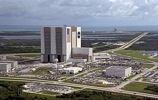
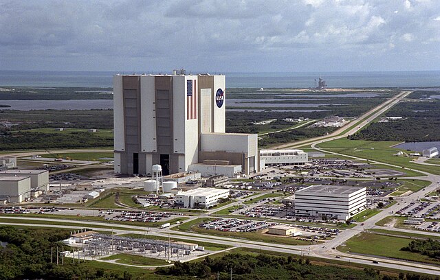
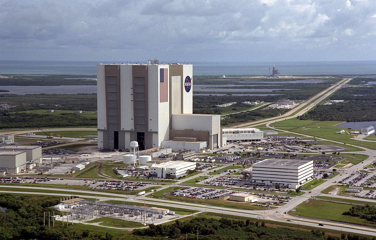
English: Kennedy Space Center - Aerial View of Launch Complex 39
An aerial view of the Launch Complex 39 area shows the Vehicle Assembly Building (center), with the Launch Control Center on its right. On the west side (lower end) are (left to right) the Orbiter Processing Facility, Process Control Center and Operations Support Building. Looking east (upper end) are Launch Pads 39A (right) and 39B (just above the VAB). The crawlerway stretches between the VAB and the launch pads toward the Atlantic Ocean, seen beyond them. At right is the turning basin where new external tanks are brought via ship. Deutsch: John F. Kennedy Space Center - Überblick über Launch Complex 39 Vehicle Assembly Building im Bildzentrum, Launch Control Center rechts davon. Am linken Rand sind (v.l.n.r.) die Orbiter Processing Facility, das Process Control Center und das Operations Support Building. Im rechts oberen Bereich ist das Launch Pad 39A. Im Hintergrund der Atlantik. |
|||||
| Päiväys | ||||||
| Lähde | ||||||
| Tekijä | NASA | |||||
| Käyttöoikeus (Tämän tiedoston uudelleenkäyttö) |
|

| Kohteen sijainti | | Tämä ja muut kuvat kartalla: OpenStreetMap |
|---|
This image or video was catalogued by one of the centers of the United States National Aeronautics and Space Administration (NASA) under Photo ID: KSC-99PP-1213. This tag does not indicate the copyright status of the attached work. A normal copyright tag is still required. See Commons:Licensing. Other languages:
|
This image or video was catalogued by Kennedy Space Center of the United States National Aeronautics and Space Administration (NASA) under Photo ID: GPN-2000-000855 and Alternate ID: 99PP-1213. This tag does not indicate the copyright status of the attached work. A normal copyright tag is still required. See Commons:Licensing. Other languages:
|
| Annotations | This image is annotated: View the annotations at Commons |
Tiedoston historia
Päiväystä napsauttamalla näet, millainen tiedosto oli kyseisellä hetkellä.
| Päiväys | Pienoiskuva | Koko | Käyttäjä | Kommentti | |
|---|---|---|---|---|---|
| nykyinen | 28. heinäkuuta 2005 kello 06.14 | | 3 000 × 1 914 (2,05 MiB) | Ed g2s | full size |
| 29. tammikuuta 2005 kello 03.43 |  | 900 × 574 (127 KiB) | BLueFiSH.as | {{PD-USGov-NASA}} |
Tiedoston käyttö
Seuraavat 4 sivua käyttävät tätä tiedostoa:
Tiedoston järjestelmänlaajuinen käyttö
Seuraavat muut wikit käyttävät tätä tiedostoa:
- Käyttö kohteessa af.wikipedia.org
- Käyttö kohteessa als.wikipedia.org
- Käyttö kohteessa ar.wikipedia.org
- Käyttö kohteessa ast.wikipedia.org
- Käyttö kohteessa az.wikipedia.org
- Käyttö kohteessa ca.wikipedia.org
- NASA
- Curaçao
- Agència Espacial Japonesa
- Agència Espacial Europea
- Cosmòdrom de Baikonur
- Malaca
- Cosmòdrom
- Cosmòdrom de Plessetsk
- Centre Espacial John F. Kennedy
- Port Espacial Europeu de Kourou
- Centre de Llançament de satèl·lits de Jiuquan
- Centre Espacial d'Uchinoura
- Agència Índia d'Investigació Espacial
- Departament de Defensa dels Estats Units
- Roscosmos
- Centre espacial de Xichang
- Usuari:Mcapdevila/Kapustin Iar
- Centre National d'Études Spatiales
- Vandenberg Air Force Base
- Centre Espacial de Tanegashima
- Comitè Coreà de Tecnologia Espacial
- Canadian Space Agency
- Plantilla:Cosmòdroms
- Base aèria de Palmahim
- Agència Espacial Israeliana
- Administració Espacial Nacional de la Xina
- Korea Aerospace Research Institute
- Centre Aeroespacial Alemany
- Esrange
- Cosmòdrom Oriental
- Centre de llançament de satèl·lits de Wenchang
- Centre de llançament de satèl·lits de Taiyuan
- Centre de Llançament Satish Dhawan
- Thumba Equatorial Rocket Launching Station
- Base aèria de Dombarovski
- Centre de Llançament Alcântara
- Centre de Llançament de Barreira do Inferno
- Agència Espacial Brasilera
- Centre de Llançament de Sohae
- Centre de Llançament de Tonghae
- Centre de Llançament de Sonmiani
- Comissió d'Investigació sobre l'Espai i l'Alta Atmosfera
- Cosmòdrom de Svobodni
Näytä lisää tämän tiedoston järjestelmänlaajuista käyttöä.