| Shire-kreivikunta
|
Sijainti
|
Hallintopiirit
|
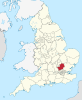
| Buckinghamshire |
 |
Aylesbury Vale, Chiltern, South Bucks, Wycombe
|
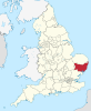
| Cambridgeshire |
 |
Cambridge, East Cambridgeshire, Fenland, Huntingdonshire, South Cambridgeshire
|
| Cumbria |
 |
Allerdale, Barrow-in-Furness, Carlisle, Copeland, Eden, South Lakeland
|
| Derbyshire |
 |
Amber Valley, Bolsover, Chesterfield, Derbyshire Dales, Erewash, High Peak, North East Derbyshire, South Derbyshire
|
| Devon |
 |
East Devon, Exeter, Mid Devon, North Devon, South Hams, Teignbridge, Torridge, West Devon
|
| East Sussex |
 |
Eastbourne, Hastings, Lewes, Rother, Wealden
|
| Essex |
 |
Basildon, Braintree, Brentwood, Castle Point, Chelmsford, Colchester, Epping Forest, Harlow, Maldon, Rochford, Tendring, Uttlesford
|
| Gloucestershire |
 |
Cheltenham, Cotswold, Forest of Dean, Gloucester, Stroud, Tewkesbury
|
| Hampshire |
 |
Basingstoke and Deane, East Hampshire, Eastleigh, Fareham, Gosport, Hart, Havant, New Forest, Rushmoor, Test Valley, Winchester
|
| Hertfordshire |
 |
Broxbourne, Dacorum, East Hertfordshire, Hertsmere, North Hertfordshire, St Albans, Stevenage, Three Rivers, Watford, Welwyn Hatfield
|
| Kent |
 |
Ashford, Canterbury, Dartford, Dover, Gravesham, Maidstone, Sevenoaks, Shepway, Swale, Thanet, Tonbridge and Malling, Tunbridge Wells
|
| Lancashire |
 |
Burnley, Chorley, Fylde, Hyndburn, Lancaster, Pendle, Preston, Ribble Valley, Rossendale, South Ribble, West Lancashire, Wyre
|
| Leicestershire |
 |
Blaby, Charnwood, Harborough, Hinckley and Bosworth, Melton, North West Leicestershire, Oadby and Wigston
|
| Lincolnshire |
 |
Boston, East Lindsey, Lincoln, North Kesteven, South Holland, South Kesteven, West Lindsey
|
| Norfolk |
 |
Breckland, Broadland, Great Yarmouth, King’s Lynn and West Norfolk, North Norfolk, Norwich, South Norfolk
|
| North Yorkshire |
 |
Craven, Hambleton, Harrogate, Richmondshire, Ryedale, Scarborough, Selby
|
| Northamptonshire |
 |
Corby, Daventry, East Northamptonshire, Kettering, Northampton, South Northamptonshire, Wellingborough
|
| Nottinghamshire |
 |
Ashfield, Bassetlaw, Broxtowe, Gedling, Mansfield, Newark and Sherwood, Rushcliffe
|
| Oxfordshire |
 |
Cherwell, Oxford, South Oxfordshire, Vale of White Horse, West Oxfordshire
|
| Somerset |
 |
Mendip, Sedgemoor, South Somerset, Taunton Deane, West Somerset
|
| Staffordshire |
 |
Cannock Chase, East Staffordshire, Lichfield, Newcastle-under-Lyme, South Staffordshire, Stafford, Staffordshire Moorlands, Tamworth
|
| Suffolk |
 |
Babergh, Forest Heath, Ipswich, Mid Suffolk, St Edmundsbury, Suffolk Coastal, Waveney
|
| Surrey |
 |
Elmbridge, Epsom and Ewell, Guildford, Mole Valley, Reigate and Banstead, Runnymede, Spelthorne, Surrey Heath, Tandridge, Waverley, Woking
|
| Warwickshire |
 |
North Warwickshire, Nuneaton and Bedworth, Rugbyn, Stratford-on-Avon, Warwick
|
| West Sussex |
 |
Adur, Arun, Chichester, Crawley, Horsham, Mid Sussex, Worthing
|
| Worcestershire |
 |
Bromsgrove, Malvern Hills, Redditch, Worcester, Wychavon, Wyre Forest
|


