Tiedosto:Uruguay fisico.png
Siirry navigaatioon
Siirry hakuun

Tämän esikatselun koko: 471 × 599 kuvapistettä. Muut resoluutiot: 188 × 240 kuvapistettä | 377 × 480 kuvapistettä | 603 × 768 kuvapistettä | 1 100 × 1 400 kuvapistettä.
Alkuperäinen tiedosto (1 100 × 1 400 kuvapistettä, 209 KiB, MIME-tyyppi: image/png)
| Tämä tiedosto on tiedostotietokanta Wikimedia Commonsista. Tiedot kuvaussivulta näkyvät alla. |  |
Tiedoston kuvaussivu Commonsissa |

|
Tämä tyyppiä map oleva kuva pitäisi luoda uudelleen SVG-tiedostoksi vektorigrafiikan avulla. Tällä tiedostotyypillä on monia vahvuuksia, sivulta Commons:Media for cleanup löytyy lisätietoja. Jos tästä kuvasta on jo olemassa SVG-versio, ole ystävällinen ja tallenna se tänne. SVG-tiedoston tallentamisen jälkeen vaihda tämä malline mallineeseen {{vector version available|uusi kuvan nimi.svg}}.
|
Yhteenveto
| Kuvaus |
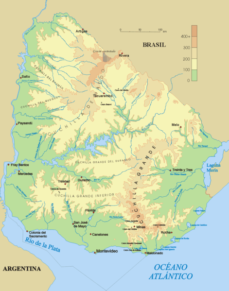
Español: Mapa físico de Uruguay.
English: Topographical map of Uruguay |
| Päiväys | |
| Lähde | Oma teos |
| Tekijä | Jordevi |
| Muut versiot |
|

Lisenssi
| Minä, tämän teoksen tekijänoikeudellinen omistaja, julkaisen tämän teoksen public domainiin eli luovun kaikista tekijänoikeuksista lain sallimissa puitteissa. Tämä on voimassa maailmanlaajuisesti. Joissain maissa laki ei mahdollista tätä. Mikäli näin on: Myönnän kenelle tahansa oikeuden käyttää tätä teosta mihin tahansa tarkoitukseen, ilman mitään ehtoja, ellei laki vaadi ehtojen asettamista. |
Tiedoston historia
Päiväystä napsauttamalla näet, millainen tiedosto oli kyseisellä hetkellä.
| Päiväys | Pienoiskuva | Koko | Käyttäjä | Kommentti | |
|---|---|---|---|---|---|
| nykyinen | 28. joulukuuta 2006 kello 06.48 | | 1 100 × 1 400 (209 KiB) | Jordevi | Mapa físico de Uruguay. Category:Maps of Uruguay |
Tiedoston käyttö
Seuraava sivu käyttää tätä tiedostoa:
Tiedoston järjestelmänlaajuinen käyttö
Seuraavat muut wikit käyttävät tätä tiedostoa:
- Käyttö kohteessa an.wikipedia.org
- Käyttö kohteessa arz.wikipedia.org
- Käyttö kohteessa ast.wikipedia.org
- Käyttö kohteessa bg.wikipedia.org
- Käyttö kohteessa ca.wikipedia.org
- Käyttö kohteessa ceb.wikipedia.org
- Käyttö kohteessa cs.wikipedia.org
- Käyttö kohteessa de.wikipedia.org
- Cuchilla de Haedo
- Cuchilla Grande
- Río Negro (Uruguay)
- Sierra Carapé
- Río Yí
- Río Tacuarembó
- Río Arapey
- Río Daymán
- Rio Quaraí
- Río Queguay
- Río Queguay Chico
- Río San Salvador
- Río Rosario
- Río Tacuarí
- Río San Juan (Uruguay)
- Río Cebollatí
- Río Arapey Chico
- Rio Jaguarão
- Río San José
- Sierra de las Ánimas
- Arroyo de la India
- Río Olimar
- Río Santa Lucía (Uruguay)
- Arroyo Grande (Río Negro, rechtsseitig)
- Benutzer:Gniesgnatz/baustelle
- Käyttö kohteessa en.wikipedia.org
- Käyttö kohteessa es.wikipedia.org
Näytä lisää tämän tiedoston järjestelmänlaajuista käyttöä.